

")


Volume 54, Nº 1 (2023)
- Ano: 2023
- ##issue.datePublished##: 14.03.2023
- Artigos: 8
- URL: https://journals.rcsi.science/2949-1789/issue/view/6687
Edição completa

Articles
To the theory of the Pliocene – Pleistocene and Holocene climate
Resumo
In this paper, an attempt to explain the main features of the planetary climate dynamics over the past ~5 Myr is made. In particular, a general cooling from the Pliocene to the Pleistocene, predominant climate variations with periodicities of 100, 41, 23–19 thousand years and the continuous nature of the spectrum are discussed. As a result, it was shown that the decrease in temperature is due to a monotonous decrease of the CO2 concentration during the Cenozoic era. This led to glaciations and restructuring the predominant climate rhythmicity of from 41ka to 100 ka years cycles with an increase in the amplitude of fluctuations. 41 ka, 23 ka and 19 ka year cycles are associated with variations in the position of the planet in its orbit and the elongation of its orbit. 100 ka rhythms exists due to the stochastic resonance of internal variability and eccentricity variations. The continuous spectrum of oscillations reflects the transfer of energy along the spectrum from the energy-carrying range due to the direct cascade, which has a Kolmogorov character. At the same time, energy transfer to the low-frequency region (inverse cascade) is also possible and associated with the effect of the Brownian process. Climate change on a century scales is associated with the inflow of energy from two sides, from long-term and short-term processes. In the first case, it is transfer from the energy-carrying Milankovitch cycles, and in the second case, it is pumping from high frequencies. Therefore, these variations, in a certain sense, are the most difficult for causal analysis. The Dansgaard–Oeschger and Heinrich oscillations, which are included in the range of centenary variations, stand apart, having a specific oceanic-glacial nature.
 3-16
3-16


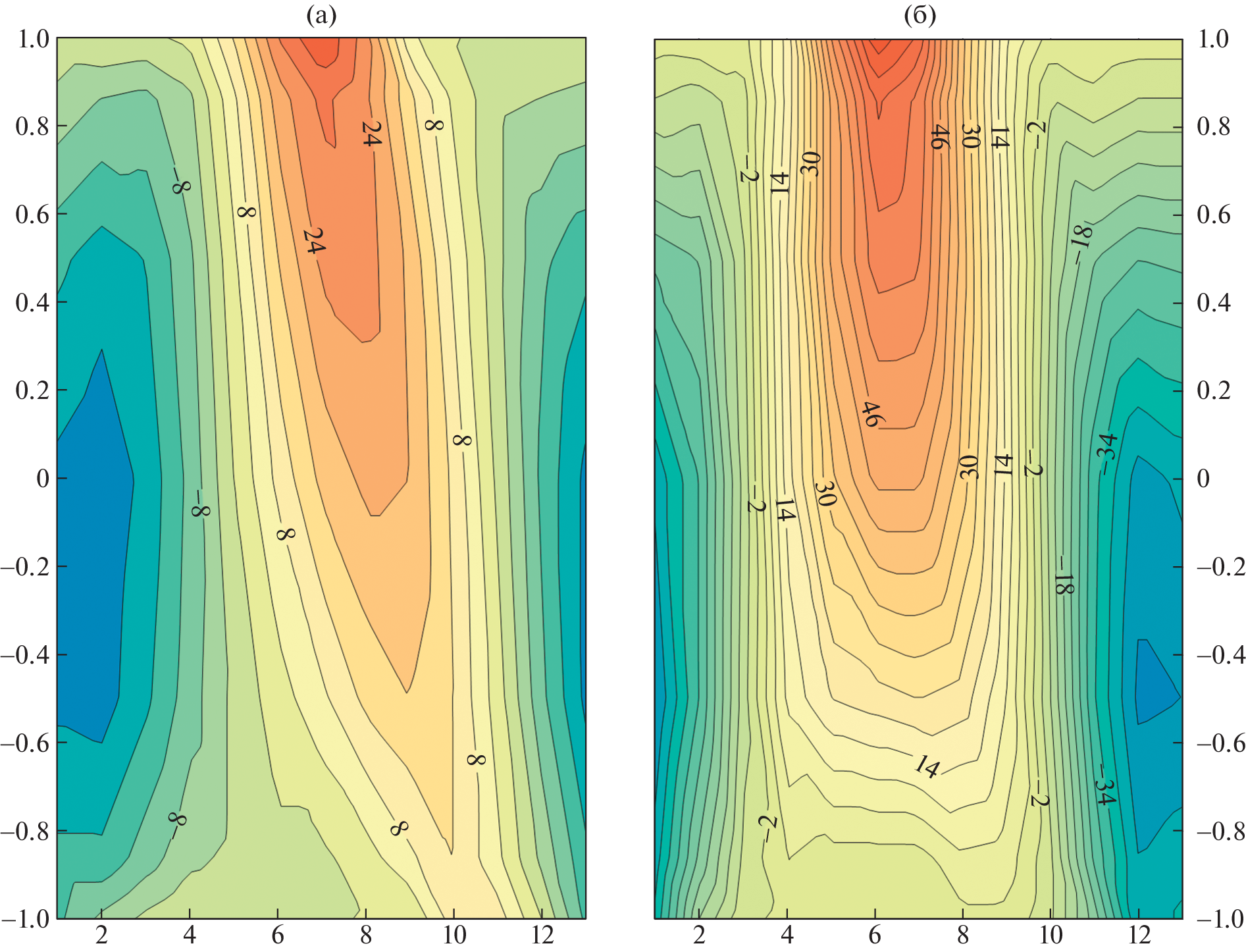
Sedimentation rates on the floodplains of lowland rivers in the center of the European Part of Russia according to the study of soil-alluvial chronosequences
Resumo
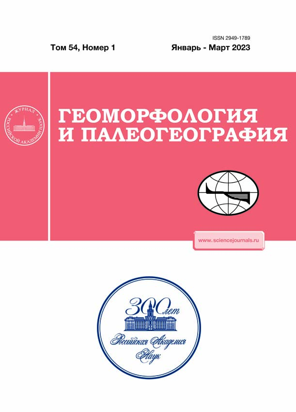
The floodplain deposition rates for the Istra, Oka and Seim rivers valleys were estimated based on a combination of dating methods (radiocarbon, radiocesium and historical-archaeological) for various time windows of the Holocene. In addition, a new method to estimated sedimentation rate, based on the assessment of the degree of soil profile development of paleosols buried in alluvium was applied. Spatio-temporal differences in the rates of floodplain sedimentation have been established based on chronological and soil-geomorphological studies. It was found that sedimentation rates on the young floodplain of Seim and Istra rivers is 1.8–23 mm year–1), 2–15 mm year–1, respectively. While on the ancient floodplains of Oka and Seim rivers during different periods, the floodplain deposition rate varied within the range of 0.01–0.7 mm year–1. The periods of increased sedimentation rates were short in time. Based on the study of a young, rapidly growing Istra River floodplain, the deposits of which are dated on the basis of historical and archaeological materials, new sedimentation rates that characterize the floodplains of the center part of the East European Plain were obtained: alluvium without signs of pedogenesis is formed at a sedimentation rate of more than 15 mm year–1, with signs of pedogenesis at a rate of 2–15 mm year–1, cumulative soils at a rate of 0.5–2 mm year–1. Cyclic fluctuations in the sedimentation rate in the Holocene were established on the basis of 14C and archaeological dates for to the Nikitino section located on the Oka River floodplain, where a large series of well-developed paleosols were distinguished. It was found that during periods with active accumulation of alluvium layers, sedimentation rate was about 2 mm year–1, which is 20 times higher than in longer periods soil formation, when sedimentation rates were 0.07–0.14 mm yr–1.
17-36
Chronology of Khvalynian Stage of the Caspian Sea according to radiocarbon dating

Resumo
The paper analyzes 234 radiocarbon dates of the Khvalynian deposits obtained by researchers over more than 50 years of studying the Caspian region. Most of the dates were obtained from shell material, including endemic species of mollusks of the genus Didacna that lived in the early and late Khvalynian basins of the Caspian Sea. The radiocarbon coverage of the Khvalynian stage is in the range of 46–8.3 cal. ka BP. The most ancient dates were obtained from the Khvalynian deposits of the Caspian Sea. The largest number of dates falls within the interval of 17–12.5 cal. ka BP. The development of the early Khvalynian transgression began 40–35 cal. ka BP. During 25–18 cal. ka BP the coastline of the early Khvalynian basin reached levels above 0–5 m asl, and the level of 20–22 m asl developed in the range of 17–13.5 cal. ka BP. After 12.5 cal. ka BP the sea level was falling probably leading to the development of Enotaevkian regression. The Upper Khvalynian deposits dated between 11–8.5 cal. ka BP probably correspond to the development of the late Khvalynian transgression. The age interval for the development of the maximum phase (45–48 m asl) of the Early Khvalynian transgression has not been determined according to the currently available data.
37-54
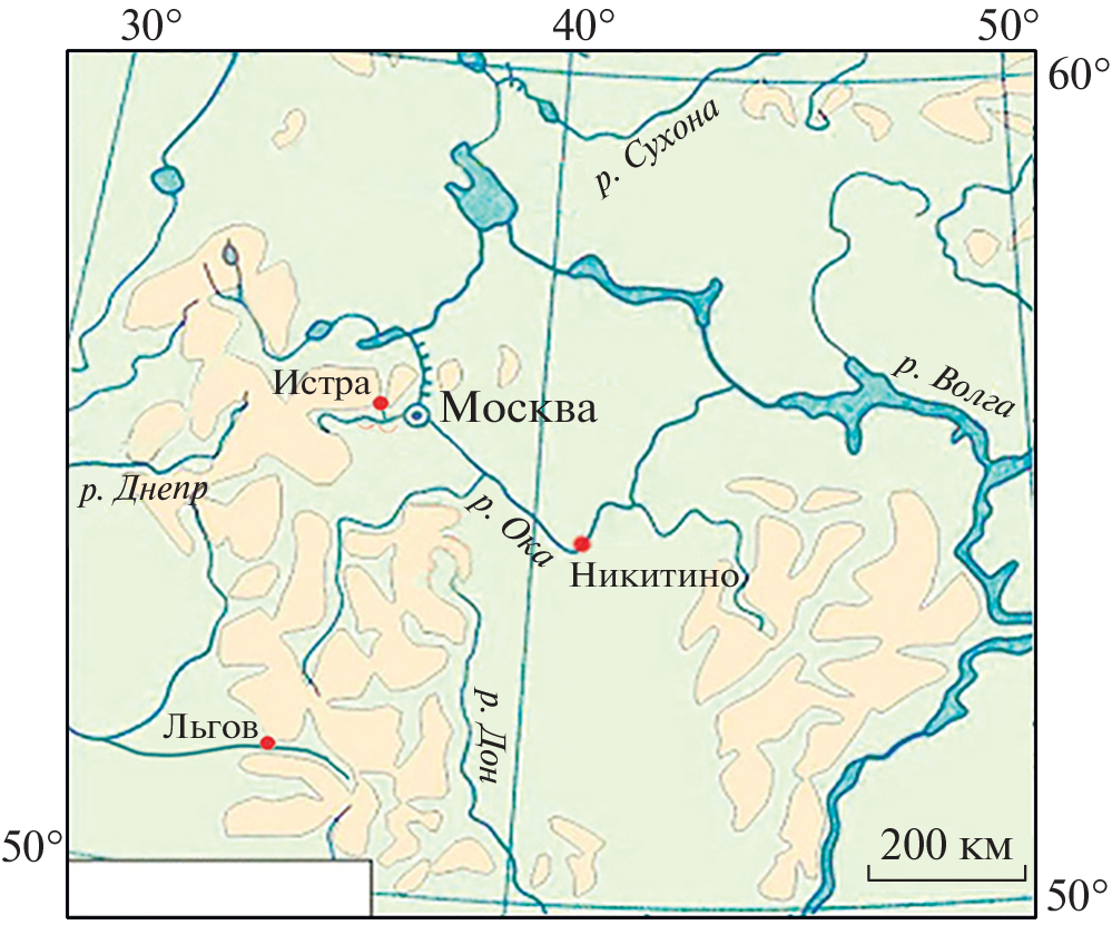
The sediment budget and migration of 137Cs in Chernobyl affected area: 30 years of investigations in the Plava River basin, Tula region
Resumo
The Plava River basin (Tula region) is considered the most polluted with Chernobyl fallout region in Russian Federation. Detailed studies of sediment redistribution and migration of 137Cs produced by Chernobyl were conducted in the basin. The article provides an overview of results from various studies conducted during the last 30 years estimating the rate of erosion and sediment redistribution based on different methodology including 137Cs. Sediment budgets for different parts of the fluvial network were developed based on estimated rates of erosion and accumulation of sediments within the Plava River basin for the post-Chernobyl period. It has been established that eroded from agricultural fields sediments accumulate on the slopes of interfluves (38.4%) and in the bottoms of dry valleys (27–38%). Part of the sediment delivered by slope runoff and temporary watercourses from the slopes of the interfluves to the bottoms of river valleys was redeposited on river floodplains (10–11%), and the remaining part (13.1–24.7%) passed into the river sediment load. The value of basin contribution of sediments to the Plava River sediment runoff is somewhat overestimated due to the specifics of the erosion models used to calculate soil erosion from arable land. It has been established that for the period of more than 25 years since the Chernobyl accident, 5% of 137Cs deposits were lost due to soil erosion (less than 0.2% annually). According to evaluated sediment budget, only a quarter of mobilized material leaves basin as a sediment yield. Thus, only about 1% of the initial 137Cs fallout was removed from the Plava basin. The perspective directions for research on sediment redistribution in the plain river basins located in the temperate zone using 137Cs as a technogenic tracer are outlined.
55-73
Kosinsky Mesolithic sites in the context of the history of the natural environment of the upper Kama region in the Late Glacial and early Holocene
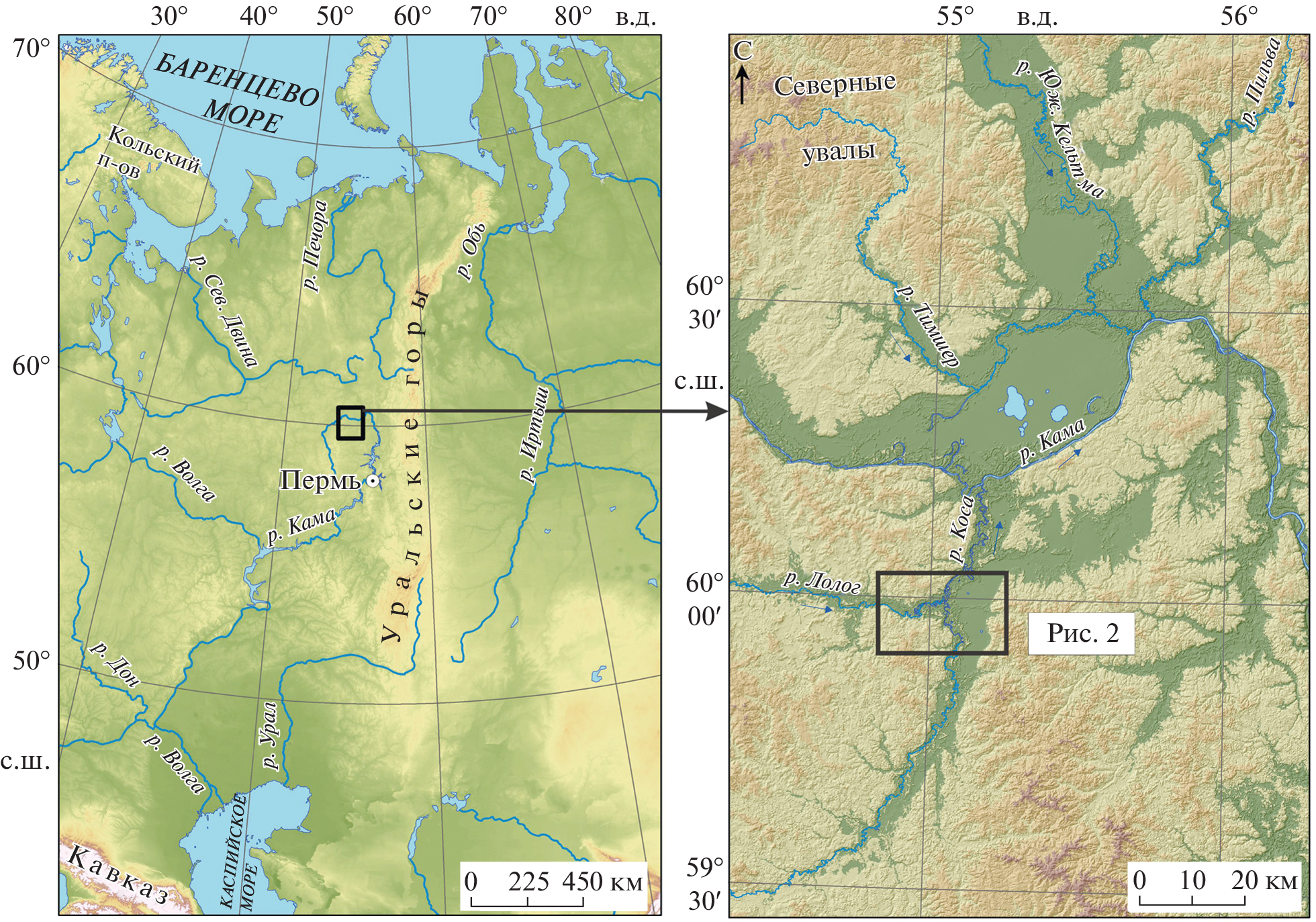
Resumo
The article presents the results of interdisciplinary (archaeological and palaeoecological) studies conducted in 2018–2021 in the northern part of the Perm Territory at the confluence of the Kosa and Lolog rivers. The main objects of research were the sites of the Mesolithic period and the natural environment of the Late Glacial and Early Holocene. To identify the confinement of archaeological sites to certain landforms within the river valley, the paleochannel method was used. As a result, 2 terraces and a Holocene floodplain were identified. For paleoenvironmental reconstruction palynological and paleocarpological methods were used. The radiocarbon method was used to create a chronological basis for the area of work. The study of the economic activities of Mesolithic groups was based on osteological analysis. In the Late Glacial period the study area was not yet inhabited by ancient people due to unfavorable natural environments. The settlement started only in the second half of the Boreal period of the Holocene, after the formation of the second terrace and the spread of taiga pine and birch forests with the participation of spruce. By this time, the sites of Kosa I and II, located on the banks of the Lolog river were inhabited. The population was mostly engaged in hunting and partly fishing. The natural environments at the beginning of the Atlantic period of the Holocene were still favorable for the existence of human groups here. Formation of the first terrace in the Lolog valley contributed to the colonization of this territory too. The Kosa III site dates back to this time, which population was still mainly engaged in hunting, and probably also fishing. Later, due to the continued lateral migration of the Kosa and Lolog river beds to the east and the emergence of waterlogged floodplains, people left this area and began to inhabit it again only in the Late Holocene.
74-89
Age of glacial and fluviogla- cial deposits of the Chibitsky glaciocomplex and its dammed lake (Gorny Altai)
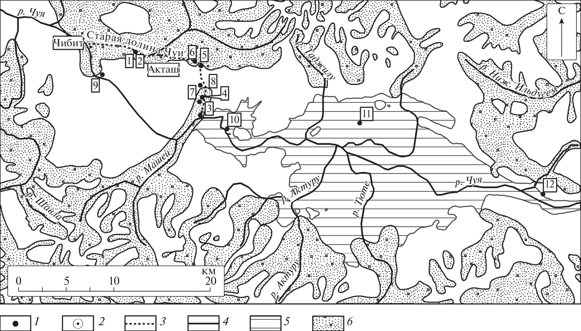
Resumo
The areal stratotype of the Chibit glaciation is characterized in the stratigraphic scheme of the Quaternary deposits of the Altai-Sayan mountainous region, corresponding to the last glacial maximum, i.e. the fourth stage of the Upper Neopleistocene of the Russian stratigraphic chart. The reference geological sections of the diamictons of the Chibit horizon are described. A Paleogeographic map showing the area of the Chibitsky and Maasheysky glaciers during the LGM is presented. The map was compiled on the basis of remote sensing materials, field geomorphological observations and field geological data. The boundaries of the glacialdammed Baratal Lake are shown based on flooding level of 1700 m. This level corresponds to the upper terraces on the northeastern edge of the Kurai depression. The boulder-gravel deposites formed as a result of the Baratal lake breakthrough were identified in the old valley of the Chuya River. They compose the 5–7 m high terrace, that is cut into the Chibit moraine. It has been established that the Chibit moraine is embedded into the Saldzhar superflood sequence. Therefore, the Saldzhar and Baratal outbursts are of different ages and scales.
90-98
Morphometric analysis of the large en- closed depression of the Southern East European plain
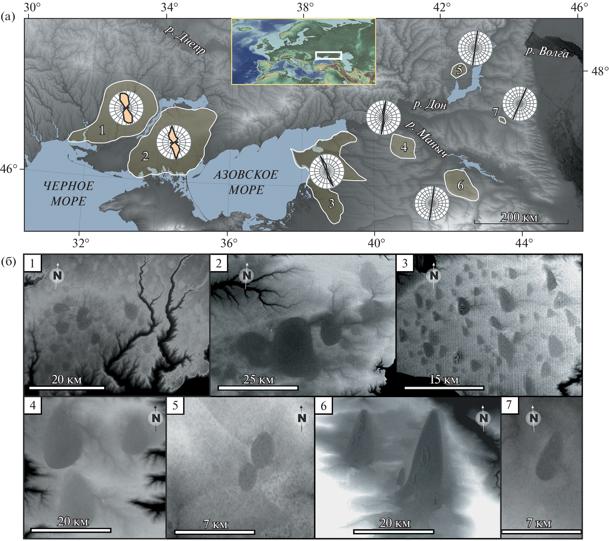
Resumo
The results of morphometric analysis based on the SRTM digital elevation model of large enclosed depressions (LEDs) of controversial origin, commonly found on the loess interfluves in the Northern Black Sea region, around the Sea of Azov, at the Western flanks of Caucus Mountains and in the Lower Don basin, are presented in the paper. We have registered 312 LEDs landforms. The morphometric characteristics of landforms vary from 0.4 to 216 km2 for area, from 1 to 21 m for depth, from 0.5 to 13.3 km for width, from 0.7 to 27.5 km for length, from 1 to 4 for elongation coefficient, and from 3.3 to 103.3 m a.s.l for height. The most common depressions have the following parameters: area – 2–4 km2; depth – 2–3 m; width – 1.0–1.5 km; length – 2.5–3.0 km; elongation coefficient – 1.2–1.4; height – 15–20 m a.s.l. There is a correlation between the area and depth of the depressions. The depressions' shape is mostly elongated, e. g. teardrop-shaped, eggshaped, elliptical, triangular, and rarely round. The sharp ends of the egg-shaped depressions always tend to point to the north, and the blunt ones – to the south. We grouped the depressions into seven restricted sites where the differences in size and other morphological features of the LEDs are very small. Within all sites, there is a high consistency of orientation of the long axes of the depressions. The largest depressions around the Sea of Azov and the Western flanks of Caucus Mountains are characterized by longitudinal ridges confined to western side of LEDs. Comparison analysis of sites demonstrated a fan-shaped pattern in changing of the long axes orientation from the NW in the Northern Black Sea region; to the East in the Azov Sea region; to the N in the Western flanks of Caucus Mountains; and the NE in the Central flanks of Caucus Mountains. A radial-centripetal pattern of the erosion network is observed across the territories where LEDs are distributed. Small erosive forms flowing into the center of depressions are represented by very flat and wide gullies and hollows with intermitted channel flow. Such morphological characteristics suggest the relict origin of the erosional forms and, as a result, indicates the pre-Holocene age of the depressions themselves. Morphological and geological data suggests that wind erosion was probably the main factor in the formation of LEDs.
99-111
Global cooling events of the Late Holocene preserved in the coastal sediments in the southern Far East of Russia

Resumo
Multy-proxy studies of the lagoon terrace in the head of the Amur Bay made it possible to identify sharp short-term cooling events during ~4450, 2870–2510, 1740–1200, and 680–380 yr BP, and compared them with cold events in other regions around the world. The reconstructions are based on results of diatom, botanical, and palynological analyzes. The Becon age model is based on radiocarbon dating and tephrostratigraphy. Tephra B-Tm from the caldera-forming Baitoushan volcano eruption was found in the section of the peat mire. The section selected to serve as a natural archive has its own specifics. In contrast to the mountainous areas and river basins, where the climate became dry 3320–3050 years ago due to a sharp decrease in the intensity of the summer monsoon, coastal lacustrine-swamp sequences had been developing in constantly waterlogged conditions. This made it possible to identify short-term dry events that well correlate with the global climatic rhythm caused by decrease in solar radiation. The decrease in moisture was closely related to the influence of the ocean: the intensity of tropical cyclogenesis, which is controlled by the activity of El Niño. The shallowing of the lagoon during the decline of low-amplitude transgression, intensified by the weakening of the summer monsoon, led to a change in terrigenous sedimentation to organogenic at about 3460 years ago. The cooling during 2870–2510 years ago had the most complex structure with sharp changes in moisture. Change in the course of swamp-forming processes around 1740 years ago associated with the activation of floods, which caused periodic flooding of the peat mire in the vast wetland near the Razdolnaya River mouth, led to the disappearance of the trees and the development of a grass swamp. In general, regional conditions were dry until the Medieval Warm Period. The landscapes responded to cooling by decreasing the role of broad-leaved trees in the forest vegetation of the low mountains, and increase of plants prefering less water-saturated habitats in the coastal plant communities. Of the cold events, the exception is the Little Ice Age, which was wet and characterized by frequent floods. The meridional transfer of moist air masses from the ocean to the continent became more active during that time.
112-130