

")


Morphometric analysis of the large en- closed depression of the Southern East European plain
- Authors: Konstantinov E.A.1, Zakharov A.L.1, Selezneva E.V.2, Filippova K.G.1
-
Affiliations:
- Institute of Geography RAS
- Obukhov Institute of Atmospheric Physics RAS
- Issue: Vol 54, No 1 (2023)
- Pages: 99-111
- Section: Articles
- URL: https://journals.rcsi.science/2949-1789/article/view/126820
- DOI: https://doi.org/10.31857/S2949178923010073
- ID: 126820
Cite item
Full Text

Abstract
The results of morphometric analysis based on the SRTM digital elevation model of large enclosed depressions (LEDs) of controversial origin, commonly found on the loess interfluves in the Northern Black Sea region, around the Sea of Azov, at the Western flanks of Caucus Mountains and in the Lower Don basin, are presented in the paper. We have registered 312 LEDs landforms. The morphometric characteristics of landforms vary from 0.4 to 216 km2 for area, from 1 to 21 m for depth, from 0.5 to 13.3 km for width, from 0.7 to 27.5 km for length, from 1 to 4 for elongation coefficient, and from 3.3 to 103.3 m a.s.l for height. The most common depressions have the following parameters: area – 2–4 km2; depth – 2–3 m; width – 1.0–1.5 km; length – 2.5–3.0 km; elongation coefficient – 1.2–1.4; height – 15–20 m a.s.l. There is a correlation between the area and depth of the depressions. The depressions' shape is mostly elongated, e. g. teardrop-shaped, eggshaped, elliptical, triangular, and rarely round. The sharp ends of the egg-shaped depressions always tend to point to the north, and the blunt ones – to the south. We grouped the depressions into seven restricted sites where the differences in size and other morphological features of the LEDs are very small. Within all sites, there is a high consistency of orientation of the long axes of the depressions. The largest depressions around the Sea of Azov and the Western flanks of Caucus Mountains are characterized by longitudinal ridges confined to western side of LEDs. Comparison analysis of sites demonstrated a fan-shaped pattern in changing of the long axes orientation from the NW in the Northern Black Sea region; to the East in the Azov Sea region; to the N in the Western flanks of Caucus Mountains; and the NE in the Central flanks of Caucus Mountains. A radial-centripetal pattern of the erosion network is observed across the territories where LEDs are distributed. Small erosive forms flowing into the center of depressions are represented by very flat and wide gullies and hollows with intermitted channel flow. Such morphological characteristics suggest the relict origin of the erosional forms and, as a result, indicates the pre-Holocene age of the depressions themselves. Morphological and geological data suggests that wind erosion was probably the main factor in the formation of LEDs.
Full Text
ВВЕДЕНИЕ
Крупные замкнутые депрессии (крупные западины, КЗ) широко распространены на лёссовых междуречных равнинах Северного Причерноморья, Приазовья, Западного Предкавказья и Нижнего Дона ( рис. 1 ). На обозначенных территориях они имеют различные местные названия – пади, падины, поды и лиманы. В отличие от так называемых “степных блюдец” (Щукин, 1980) рассматриваемые депрессии имеют на порядок большие размеры. Их протяженность варьирует от первых километров до более чем двух десятков километров. Глубина варьирует от первых метров до десятков метров, а площадь – от 1 до 200 км 2 . Форму они имеют преимущественно вытянутую (каплевидную, яйцевидную, эллиптическую, треугольную) и редко округлую. КЗ бывают плохо различимы на местности, так как имеют плавные черты элементов рельефа при своих крупных размерах.

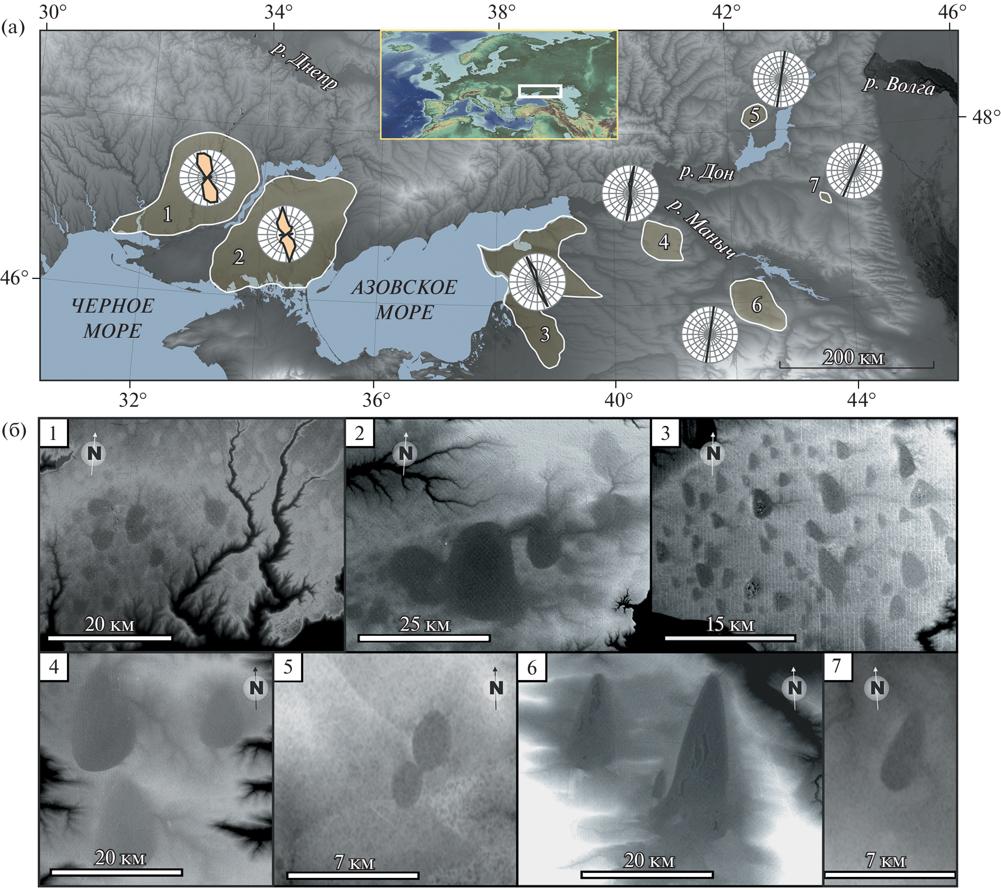
Рис. 1. Распространение крупных западин на юге Восточно-Европейской равнины. (а) – положение ареалов распространения крупных западин; (б) – структура западинного рельефа в выделенных ареалах. Роза-диаграммы на карте (а) показывают направления длинных осей западин. Топографическая основа – модель SRTM. Fig. 1 . Distribution of large oriented depressions in the south of the East European Plain. (a) – position of large oriented depressions sites; (б) – structure of relief in selected sites. The rose diagrams on the map (a) show the directions of the long axes of large oriented depressions. The topographic base is the SRTM model.
Анализ опубликованной литературы, посвященной проблеме происхождения крупнозападинного рельефа междуречий юга Восточно-Европейской равнины (Лисицин, 1932; Денисов, 1946; Левандовский, 1956; Кавеев, 1957; Рубинштейн, 1961; Ларионов, 1970; Сафронов, 1973; Булавин, 1977; Канонников, 1977; Кочетов, 1978; Молодых, 1982; Сафронов, 1987; Kleschenkov, 2010; Востриков, 2012) показал, что взгляды исследователей существенно расходятся. Имеющиеся на данный момент представления о происхождении этих форм рельефа противоречивы и часто слабо подкреплены фактическим материалом. Ни одна из выдвинутых в разные годы гипотез (просадочно-лёссовая, палеотермокарстовая, эрозионно-суффозионная, лиманно-озерная, тектоническая) не имеет на сегодняшний день достаточного обоснования или аргументированного опровержения. Такая неопределенность связана со слабой изученностью геолого-геоморфологического строения западин. Причем морфология исследуемых депрессий, как правило, освещена хуже геологического строения. Основные представления об их строении и происхождении разрабатывались в середине XX века, в период широкомасштабных инженерно-геологических изысканий по изучению просадочных явлений в лёссах (Денисов, 1946; Кавеев, 1957; Молодых, 1982). В последнее время появились исследования геологического строения отдельных депрессий (Захаров, Константинов, 2019).
В определенной степени слабая изученность морфологии западин может объясняться чисто технической проблемой, связанной с изображением западин на топографических картах. Разрыв между плановыми размерами этих объектов и их глубиной достигает нескольких порядков. Эта особенность затрудняет работу с топографическими картами среднего масштаба, так как западины на них практически не читаются из-за недостаточно частого сечения горизонталей. При использовании же крупномасштабных карт возникает другая проблема: на них можно подробно рассмотреть топографию отдельных западин, но при этом не видно взаиморасположения объектов, т.е. теряется общая структура западинного рельефа. С появлением в последние два десятилетия свободно распространяемых цифровых моделей рельефа (ЦМР) приемлемого разрешения (ASTER, SRTM, ALOS и др.) проблема масштаба и визуализации западинного рельефа практически отпала, а в руках у исследователей появился удобный инструмент анализа морфологии земной поверхности, ее количественных и качественных характеристик.
Попытки использования ЦМР для морфологического анализа западин Ейского полуострова и южного побережья Таганрогского залива уже предпринимались в недавних работах (Kleschenkov, 2010; Захаров, Константинов, 2013). В указанных работах были получены количественные характеристики размеров и формы выявленных объектов, рассчитаны статистические коэффициенты, предприняты попытки морфометрической классификации. Все это открыло возможности для поиска потенциальных форм-аналогов на равнинах земной суши на основе сравнения морфометрических параметров западин.
В настоящей работе рассматриваются уже не отдельные ареалы, а вся совокупность дешифрируемых на основе модели SRTM крупных западин, покрывающих лёссовые равнины Приазовья, Северного Причерноморья и Предкавказья. Исследование нацелено на получение генетически значимой количественной информации о крупнозападинном рельефе, способствующей продвижению в вопросе механизмов образования данного комплекса форм. В задачи работы входят получение и систематизация морфологических данных по крупно-западинному рельефу.
РАСПОЛОЖЕНИЕ ОБЪЕКТОВ И МЕТОДИКА ИССЛЕДОВАНИЯ
Пояс крупнозападинного рельефа протягивается в субширотном направлении от Березанского лимана на западе до долины р. Маныч на востоке и Цимлянского водохранилища на северо-востоке. Депрессии распространены среди лёссовых низменностей степной зоны, их распространение не зависит от тектонического и дочетвертичного геологического строения. Абсолютные высоты в пределах изучаемой территории изменяются от 0 до 105 м, а большая часть западин лежит ниже 70 м ( рис. 2 ). Междуречья и речные террасы покрыты лёссовым чехлом (Velichko, 1990; Haase et al., 2007), мощность которого варьирует от нескольких метров до 40–50 м (Балаев, Царев, 1964; Молодых, 1982; Tesakov et al., 2007; Velichko et al., 2012; Konstantinov et al., 2018). Западины распределены не равномерно по рассматриваемой территории, а сгруппированы в обособленные ареалы ( рис. 1 , (а)), внутри которых наблюдается специфика размеров и форм этих образований. Количество западин сильно варьирует между ареалами – от нескольких западин до более чем сотни объектов. Всего можно выделить семь ареалов ( рис. 1 , (б)) распространения крупных западин, в которых нами было зафиксировано 312 таких форм. Повышенные мощности лёссов тяготеют к востоку изучаемой территории – Западному Предкавказью и бортам долины р. Маныч. Максимальных значений (40–50 м) мощность лёссового чехла достигает у подножья северного склона Ставропольской возвышенности в районе ареала 6 (Балаев, Царев, 1964).

Рис. 2. Распределение крупных западин по высотам. Fig. 2. Distribution of large oriented depressions by altitude.
Для выбора цифровой модели рельефа, которая бы максимально корректно воспроизводила топографию изучаемого региона, нами был поставлен эксперимент по сопоставлению топографических профилей, построенных на основе различных свободно распространяемых ЦМР с нивелирными профилями. Полностью покрывают районы исследований и при этом находятся в свободном доступе следующие модели: ALOS World 3D, ASTER GDEM, SRTM. Все модели относятся к глобальным и характеризуются пространственным разрешением от 1 до 3 угловых секунд (от 20 до 60 м в широтном направлении, от 30 до 90 м в меридиональном). Помимо этого, модели отличаются разными величинами погрешностей определения высот и, как следствие, морфометрических характеристик.
Сопоставление проводилось по двум линиям нивелирования в пределах Воронцовской пади и Лимана Большого ( рис. 3, (г), (д)). Суммарная протяженность топографических профилей составила 6.2 км, они включают 171 точку. Оценка вертикальной точности проведена как визуально – сопоставление линий профилей по данным нивелирования и ЦМР, так и численно – были рассчитаны средняя ошибка (ME) и ее стандартного отклонения (SD) ( табл. 1 ). При визуальном анализе заметен высокий уровень “шума” (случайных ошибок) у моделей ALOS и ASTER. Наименьшим уровнем “шума” отличается SRTM. Также при вычитании средней ошибки, которую при большой выборке можно интерпретировать как систематическую, эта модель оказывается точнее остальных, и поэтому была выбрана для дальнейшего анализа.

Рис. 3. Топография крупнейших западин ареала 3. (а) – обзорная карта, (б) – падь Крикунова, (в) – Червоная падь, (г) – Воронцовская падь, (д) – Лиман Большой, (е) – Кугейская падь. Fig. 3 . Topography of the largest oriented depressions of the site 3. (а) – overview map, (б) – Pad’ Krikunova, (в) – Chervonaya Pad’, (г) – Vorontsovskaya Pad’, (д) – Liman Bol’shoy, (е) – Kugeiskaya Pad’.
Таблица 1. Сравнение ошибки цифровых моделей рельефа по результатам эксперимента. Table 1. Comparison of the error of digital elevation models according to the results of the experiment
ЦМР | ME, м | SD, м |
ASTER GDEM v.2 | 1.6 | 4.7 |
ALOS World 3D – 30 m | 3.0 | 1.2 |
SRTM Plus v.3 | 3.3 | 1.1 |
Примечание. ME – средняя ошибка, SD – стандартное отклонение. Note. ME – mean error, SD – standard deviation.
Для выбранной модели заявлены следующие параметры (Rodriguez et al., 2006; Farr et al., 2007): пространственное разрешение – 1 угловая секунда, для Евразии ошибка при вычислении координат – 8.8 м, абсолютная ошибка по высоте – 6.2 м, относительная ошибка по высоте – 8.7 м.
С помощью картографического пакета “GlobalMapper-19” на основе SRTM было произведено измерение 312 выявленных западин. По результатам измерений составлена база данных западин ( табл. 2 ), включающая набор морфометрических параметров для каждой формы: площадь, глубина, длина, ширина, азимут ориентировки длинной оси и коэффициент вытянутости. Полученные числовые данные статистически анализировались с использованием программы MS Excel.
Таблица 2. Морфометрические характеристики крупных западин в выделенных ареалах. Table 2. Morphometric characteristics of large depressions in the selected areas
Ареал | Статистический показатель | S, км2 | H, м | FF, шт | W, км | L, км | L / W | ALT, м абс. |
Ареал 1 (124 КЗ) | Среднее | 6.5 | 3 | 0.2 | 2.2 | 3.1 | 1.5 | 61.1 |
| Мода | 2.0-4.0 | 2-3 | - | 1.5-2 | 2.5-3 | 1.2-1.4 | 50-55 |
| Минимум | 0.9 | 1 | 0 | 0.8 | 1.3 | 1 | 37.5 |
| Максимум | 49.1 | 6 | 4 | 6.9 | 9.6 | 2.6 | 103.3 |
Ареал 2 (45 КЗ) | Среднее | 33.3 | 5.5 | 1.2 | 4.7 | 7.2 | 1.6 | 52.5 |
| Мода | 4-6 | 3-4 | - | 2-2.5 | 3.5-4 | 1.2-1.4 | 65-70 |
| Минимум | 2.9 | 1.5 | 0 | 1.7 | 2 | 1.1 | 4.9 |
| Максимум | 199 | 18 | 7 | 13.3 | 19.6 | 2.7 | 93.1 |
Ареал 3 (133 КЗ) | Среднее | 4.2 | 3.9 | 1.0 | 1.6 | 2.7 | 1.8 | 20.6 |
| Мода | 0.4-2 | 2-3 | - | 1-1.5 | 1.5-2 | 1.6-1.8 | 15-20 |
| Минимум | 0.4 | 1.5 | 0 | 0.5 | 0.9 | 1 | 3.3 |
| Максимум | 53.9 | 21 | 13 | 5.2 | 12.9 | 4 | 49.1 |
Ареал 4 (4 КЗ) | Среднее | 114.1 | 8.1 | 1.8 | 9.3 | 13.8 | 1.6 | 96.3 |
| Минимум | 7.3 | 2 | 0 | 2.1 | 4.5 | 1.2 | 94.3 |
| Максимум | 195 | 11.3 | 4 | 13.2 | 20.4 | 2.2 | 98.3 |
Ареал 5 (2 КЗ) | Среднее | 3.9 | 5.3 | 2 | 2 | 2.6 | 1.3 | 68.6 |
| Минимум | 3 | 4.7 | 1 | 1.8 | 2.1 | 1.2 | 68.4 |
| Максимум | 4.7 | 5.8 | 3 | 2.2 | 3 | 1.4 | 68.8 |
Ареал 6 (3 КЗ) | Среднее | 106.5 | 6.5 | 2 | 7.8 | 16.2 | 2.1 | 61.5 |
| Минимум | 8.1 | 2 | 0 | 2.2 | 5.1 | 2 | 60.3 |
| Максимум | 216.8 | 10 | 4 | 13.3 | 27.5 | 2.3 | 62.8 |
Ареал 7 (1 КЗ) | Параметры | 7.5 | 5 | 2 | 2 | 4.7 | 2.3 | 63.8 |
Всего 312 объектов | Среднее | 11.7 | 3.8 | 0.8 | 2.3 | 3.7 | 1.6 | 43.1 |
| Мода | 2-4 | 2-3 | - | 1-1.5 | 2.5-3 | 1.2-1.4 | 15-20 |
| Минимум | 0.4 | 1 | 0 | 0.5 | 0.9 | 1 | 3.3 |
| Максимум | 216.8 | 21 | 13 | 13.3 | 27.5 | 4 | 103.3 |
Примечание. S — площадь; H — глубина; FF — число притоков (ложбины, балки); W — ширина; L — длина; L/W — коэффициент удлиненности; ALT — высота днища над уровнем моря; (—) — нет данных. Note. S — area; H — depth; FF — the number of tributaries (hollows, beams); W — width; L — length; L/W — coefficient of elongation; ALT — bottom height a.s.l.; (-) — no data.
РЕЗУЛЬТАТЫ: МОРФОМЕТРИЧЕСКИЕ ХАРАКТЕРИСТИКИ ЗАПАДИН
Ареал 1. В пределах ареала зафиксированы 124 крупные западины. Они распространены на междуречных пространствах от Березанского лимана на юго-западе до Каховского водохранилища на северо-востоке ( рис. 1, (б)–1). Территория расчленена долинами рек Южный Буг, Ингул, Ингулец, Днепр и их притоками. Поверхность имеет пологий наклон в направлении с севера на юг. Средний уклон равен 0.0007, падение составляет 0.7 м на 1 км. Абсолютные высоты изменяются от 30 до 90 м. Западины равномерно распределены по территории, 86% их них не имеют выраженных балок-притоков. Редко встречаются формы с одним-двумя притоками, в единичном случае их количество достигает четырех. Часть форм имеет связь с соседними западинами через небольшие долины. Днища депрессий ровные, субгоризонтальные, что не согласуется с общим уклоном фоновой поверхности. Северные склоны КЗ, как правило, немного выше южных. Элементы морфологии западин (бровки и тыловые швы) очень плавные, без резких границ. Плановая форма большинства КЗ близка к овальной, реже встречаются западины яйцевидной формы. 82% депрессий имеет не изометричную форму, т.е. они вытянуты. Коэффициент вытянутости в среднем 1.5. Из числа вытянутых депрессий 59% КЗ направлена по азимуту 330–360°. Площадь объектов меняется от 0.9 до 49.1 км 2 ( рис. 4 ). В среднем она составляет 6.5 км 2 , а модальный интервал составляет 2–4 км 2 . Глубина достигает 6 м, но модальное значение не превышает 2–3 м. Коэффициент корреляции между площадью и глубиной составляет 0.53.

Рис. 4. Гистограмма распределения крупных западин по площади. Fig. 4. Histogram of the distribution of large oriented depressions by area.
Ареал 2. В пределах ареала зафиксировано 45 крупных западин. Территория, на которой распространены КЗ, относится к междуречью рек Днепра и Молочной ( рис. 1, (б)–2). Поверхность разделена на две обширные слабонаклонные террасы (30 и 70 м абс.). Склон между террасами протяженный, около 30 км, и пологий. Средний уклон равен 0.0012 – падение 1.2 м на 1 км. КЗ распространены равномерно на обеих террасах и на склоне. На юге ареала КЗ затоплены и становятся частью береговой линии оз. Сиваш.
Эрозионная сеть представлена в основном балками. Долины с постоянными водотоками единичны. Крупнейшие долины ориентированы по общему уклону поверхности – с севера на юг. Значительная часть поверхностного стока перехватывается западинами, особенно крупнейшими, расположенными на нижней террасе. 25 КЗ не имеют впадающих балок-притоков. Больше двух балок-притоков имеет девять КЗ, а максимальное число притоков (семь) имеют две КЗ. Одиннадцать западин имеют соединения с соседними формами. Часть из них сливается, образуя общее днище. Наблюдается также и другой тип слияния – соединения КЗ небольшими сухими долинами-протоками.
Днища депрессий преимущественно плоские и субгоризонтальные, что не согласуется с общим уклоном поверхности. Это проявляется в асимметрии бортов части КЗ – северные склоны высокие и крутые, южные – низкие пологие. Особенно это заметно у крупных западин, распространенных на склоне между террасами. Плановая форма большинства КЗ неправильная фасолевидная. Как правило, такие КЗ имеют неровные склоны, сильно трансформированные линейной эрозией. Две КЗ имеют яйцевидную форму с четкими ровными бортами.
39 из 45 западин имеют вытянутую форму. Коэффициент удлиненности в среднем 1.6. Длинные оси 51% КЗ имеют азимут ориентировки в интервале от 345 до 360°. 25% КЗ имеют азимут ориентировки от 0 до 30°. Площадь объектов изменяется от 2.85 до 199 км 2 ( рис. 4 ). В среднем площадь составляет 33.3 км 2 , а модальный интервал 4–6 км 2 . В данном ареале много очень крупных западин (>45 км 2 ) – девять. Максимальная глубина достигает 18.4 м, но модальное значение не превышает 3.5 м. Коэффициент корреляции между площадью и глубиной составляет 0.52.
Ареал 3. Ареал протягивается вдоль восточного побережья Азовского моря, от дельты Дона на севере до Кубанских плавней на юге ( рис. 1, (б)–3). Здесь зафиксированы 133 КЗ. Размеры ареала примерно 160 × 120 км. Фоновая поверхность здесь имеет общий слабый уклон с востока на запад. Абсолютные высоты изменяются от 70 до 4 м абс. Рельеф осложняет разветвленная система пологих долин малых рек и балок, которые имеют два главных направления: ЮВ–СЗ и З–В. Наиболее крупные долины принадлежат малым рекам Бейсуг, Сосыка, Ея и Кагальник. Междуречные пространства покрыты КЗ. Причем КЗ распространены неравномерно. Количество депрессий увеличивается с востока на запад, а их максимальная плотность и выраженность достигаются на Ейском полуострове.
Для КЗ характерна очень высокая согласованности ориентировки длинных осей западин. 89% всех депрессий имеет азимут 330–360°. Значительная часть КЗ выстроена в линейные цепочки (по 2–5 западин), ориентация которых совпадает с ориентацией отдельных западин. Для западин характерны плавные и ровные контуры, правильные (без фестонов) борта и вытянутая яйцевидная форма с наличием тупого и острого концов. Причем острый конец всегда направлен на СЗ, а тупой на ЮВ. В редких случаях форма западин тяготеет к треугольной.
Наиболее распространенными являются западины со значениями коэффициента удлиненности 1.6–1.8, характерная их площадь лежит в интервале 0.4–4 км 2 , таких относительно малых форм большинство – 71% ( рис. 4 ). Самые мелкие западины (<1 км 2 ) составляют 17% от общего числа форм. Средних по размеру западин (4–10 км 2 ) 19.5%. Крупных форм, площадь которых более 10 км 2 , всего двенадцать (9%). Особняком стоит огромная Кугейская падь ( рис. 3, (е)), площадь которой составляет 53.9 км 2 . Глубина западин варьирует в пределах от 1.5 до 21 м. Между площадью и глубиной наблюдается сильная линейная связь – коэффициент корреляции площади и глубины составляет 0.83. Большинство западин имеет примерно одинаковые пропорции, слабо варьирующие при изменении размеров.
Размах высот в пределах днища западин редко превышает 1–2 м. Западная часть днища самых крупных форм осложнена пологими субпараллельными грядами высотой 3–5 м: падь Крикунова, Червоная падь, Воронцовская падь, Лиман Большой, Кугейская падь ( рис. 3, (б), (е)). Гряды ориентированы вдоль длинной оси западин.
Малые эрозионные формы, балки и ложбины, имеют радиально центростремительный рисунок, привязанный к КЗ. При этом балки, впадающие в западины с востока, обычно в 5–10 раз больше по протяженности, что объясняется общим пологим уклоном территории в западном направлении. В КЗ впадает в среднем одна балка, максимальное число достигает тринадцати.
Ареал 4. В пределах ареала зафиксировано четыре КЗ, которые обладают исключительно крупными размерами ( рис. 1, (б)–4). Ареал принадлежит вершинной поверхности междуречья и расположен к востоку от верховьев р. Кагальник и к юго-западу от р. Маныч. Абсолютные высоты изменяются здесь от 90 до 110 м абс. Территория обрамлена многочисленными балками и верховьями речных долин. КЗ расположены отдельно друг от друга, не имеют точек слияния и общих долин. Форма западин яйцевидная, близкая к треугольной. Северные оконечности КЗ узкие, а южные – широкие. Суженные оконечности КЗ направлены по азимутам 182, 184, 181 и 179°. В КЗ впадает до четырех балок без постоянных водотоков. Коэффициент вытянутости в среднем 1.6. Линейные размеры крупнейшей западины ареала 4 составляют 13.2 × 20.4 км. Площадь зафиксированных КЗ составляет, соответственно, 195, 81.5, 172.4 и 7.3 км 2 . Глубины изменяются от 2 до 11.3 м.
Ареал 5. В пределах ареала зафиксировано 2 КЗ ( рис. 1, (б)–5). Территория представлена фрагментом террасы Дона средней высотой 65–80 м абс., который окружен с трех сторон Цимлянским водохранилищем. Днища депрессий ровные. Склоны прямые, элементы склонов четкие и выраженные. Форма КЗ близка к эллиптической. В КЗ впадает до трех балок без водотоков. КЗ имеют участок слияния. Коэффициент удлиненности составляет 1.2 и 1.4. Площади составляют 3 и 4.7 км 2 . Депрессии ориентированы по азимутам 7 и 12°. Глубины составляют 4.7 и 5.8 м.
Ареал 6. В пределах ареала зафиксировано 3 КЗ ( рис. 1, (б)–6). Территория представлена низменностью, расположенной межу Ставропольской возвышенностью и долиной р. Маныч. Высоты здесь изменяются от 55 до 75 м абс. Южнее, на отрогах Ставропольской возвышенности, высоты достигают 180 м абс. Западины имеют очень крупные линейные размеры: 7.9×16 км (Лиман Малый Бурукшун), 2.2 × 5.1 км (б/н), 13.3 × 27.5 км (Лиман Большой Бурукшун). Площади составляют 94.6, 8.1 и 216.8 км 2 . Причем форма Лиман Большой Бурукшун имеет самую большую длину и площадь среди всех зафиксированных нами КЗ. Глубины составляют 7.4, 2 и 10 м соответственно. Депрессии ориентированы по азимутам 6 и 7°. Они очень вытянуты, имеют высокие коэффициенты удлиненности – 2.0, 2.3, 2.1. Плановая форма двух крупнейших КЗ напоминает морковины с острым северным концом и усеченной южной оконечностью. Третья КЗ значительно меньше и расположена на междуречье между двумя крупными депрессиями. Ее форма близка к вытянутому эллипсу. В днище депрессий присутствуют небольшие озера. На северном склоне крупнейшей из КЗ проложена дренажная канава, контролирующая уровень воды в депрессии. В КЗ впадает до четырех балок без водотоков.
Ареал 7. Здесь зафиксирована только одна КЗ ( рис. 1, (б)–7). Территория представлена междуречьем высотой 65–70 м абс., с севера и востока ограниченным долиной р. Сал. В КЗ впадают две балки без водотоков. Днище депрессии ровное, субгоризонтальное. Форма КЗ близка к вытянутому яйцу. Северная оконечность острая, южная тупая. Края западины ровные и четкие. Линейные размеры – 2 × 4.7 км. Коэффициент удлиненности 2.32. Депрессия ориентирована по азимуту 20°. Площадь составляет 7.49 км 2 . Глубина достигает 5 м.
ОБСУЖДЕНИЕ РЕЗУЛЬТАТОВ
Характер распространения западин и эрозионная сеть. Рассматриваемый комплекс форм имеет не сплошное распространение, а разделен на обособленные ареалы. Причем между ареалами имеются характерные различия в размере и форме западин. Внутри ареалов наблюдается слабое развитие эрозионной сети – это отчетливо видно при сравнении рельефа с соседними районами, где не развит крупнозападинный рельеф. Западины присутствуют в высотном диапазоне от 3.3 до 103.3 м абс. ( табл. 2 ), при этом большая часть (71%) западин приурочена к высотам ниже 60 м абс. ( рис. 2 ). А самый крупный по числу западин ареал 3 целиком расположен ниже 50 м абс. Из этого видно, что западины тяготеют к низким высотным ступеням. Для этих ступеней характерны относительно низкая глубина и густота эрозионного расчленения.
Однако эрозионные формы все же присутствуют. Их густота закономерно растет с увеличением уклонов и абсолютной высоты. Эрозионные формы ареалов распространения КЗ представлены редкими широкими речными долинами, пологими балками и ложбинами, а также оврагами, которые приурочены к морским береговым обрывам. Типична ситуация, когда западины служат приемным бассейном для стока по балкам и ложбинам. Для таких малых эрозионных форм характерен радиальный центростремительный рисунок эрозионной сети. Ложбины и балки как бы обрамляют западины. Число форм-притоков у западин растет с увеличением площади западин и может достигать 13, но чаще составляет 2–3. С ростом уклона фоновой поверхности растет протяженность балок и ложбин. Так, крупнейшие западины в ареале 2, расположенные на склоне между террасами, имеют очень длинные древовидные балки-притоки, впадающие с севера – их длина изменяется от 15 до 45 км. В днищах таких крупных балок есть практически постоянные водотоки, а в их устьях выражены конусы выноса.
Отсутствуют примеры пересечения КЗ долинами, когда западина была бы разрезана на две части. Это косвенно указывает на то, что западины моложе раннего плейстоцена – этапа, когда на аллювиально-морских террасах начинали закладываться речные долины (Konstantinov et al., 2018). С другой стороны, западины очевидно древнее ложбин и балок, впадающих в западины. С учетом того, что возраст большинства балок и ложбин оценивается как средний-поздний плейстоцен (Konstantinov et al., 2018), можно предположить, что возраст западин как минимум доголоценовый, а вероятнее всего – среднеплейстоценовый.
Подавляющее большинство КЗ замкнуто и не имеет выраженных в рельефе каналов стока наружу. Однако у части КЗ такие каналы все же присутствуют, иногда соседние западины смыкаются краями. Такие проявления характерны для небольшого числа КЗ ареалов 1, 2 и 5. Особенно ярко это выражено у крупных КЗ ареала 2 ( рис. 1, (б)–2). Соединительные каналы могут говорить о процессах стока воды из верхних КЗ в нижние. Сток приводил к частичной эрозии водораздела и образованию выраженных в рельефе соустьев. Все это может говорить о вероятном заполнении части КЗ озерами в прошлом. Про озерный режим КЗ ареала 2 косвенно говорит несоответствие уклонов: субгоризонтальные днища КЗ соседствуют с наклонной фоновой поверхностью междуречья. Это может объясняться выравниванием поверхности днища КЗ за счет озерной седиментации. В крупнейшей западине ареала 6 и сейчас наблюдаются небольшие водоемы, которые еще недавно (до строительства дренажного канала) могли затоплять все днище. Как видно из примеров, формирование озер в днище более вероятно для очень крупных КЗ с большим водосборным бассейном. Подавляющее большинство КЗ имеет существенно меньшие размеры и площади водосбора, и следов береговых или флювиальных форм у них не наблюдается.
Область развития крупно-западинного рельефа расположена южнее реконструируемой границы многолетнемерзлых пород плейстоценовых оледенений (Величко, 1973; Vandenberghe et al., 2012). Гипотетически возможная островная мерзлота и глубокое сезонное промерзание (Величко и др., 2013) не сочетаются с широким развитием термокарста и формированием аласо-подобных форм. Все это в совокупности с отсутствием следов явных криогенных деформаций в многочисленных разрезах лёссово-почвенной серии Приазовья (Величко и др., 2009, 2012; Konstantinov et al., 2018; Mazneva et al., 2021) делает термокарстовую гипотезу маловероятной.
Размеры и форма западин. Размеры КЗ изменчивы в большом диапазоне величин ( табл. 2 ). Также значительно изменяется форма КЗ, что было показано в разделе, посвященном результатам. Остановимся здесь лишь на нескольких примерах такой изменчивости. Так, все западины ареала 4 имеют очень крупные размеры и характерную каплевидную форму с боковой асимметрией. Западины ареала 6 очень крупные, удлиненные, имеют специфическую форму морковин. Западины ареала 5 представлены эллиптическими формами, частично слившимися друг с другом. Западины 1 и 2 ареалов имеют невысокие значения коэффициента удлиненности ( рис. 3 ). Для них характерны эллиптические и фасолевидные формы, и здесь редко встречаются яйцевидные и каплевидные КЗ. Для ареала 3, напротив, характерны более вытянутые формы – яйцевидные и даже треугольные КЗ.
Обозначенные особенности размеров и формы КЗ в разных ареалах говорят о локальной специфике процессов их образования и последующей трансформации с течением времени. Вместе с тем между ареалами генетическая связь у западин также прослеживается, хотя и более слабая. Так, во всех ареалах, кроме пятого, можно встретить КЗ с характерной асимметрией концов – когда один конец острый, а другой тупой (яйцевидные, каплевидные, морковевидные). При этом острый конец всегда направлен на север, а тупой – на юг.
Вызывает вопрос большой разрыв в размерах западин. Линейные размеры могут отличаться более чем на один порядок. Могут ли крупнейшие западины быть родственны средним и мелким по размеру формам? В пользу того, что западины разных размеров генетически связаны, говорят очевидное сходство их формы и сохранение пропорций при изменении размера. Это подтверждается установленной корреляцией площади и глубины.
В то же время у самых крупных западин могут наблюдаться специфические особенности форм, которых нет у мелких депрессий. Так, в ареале 3 выделяются пять крупнейших западин, у которых наблюдаются продольные гряды, протягивающиеся вдоль западного борта ( рис. 3 ). У западин среднего размера прослеживается слабозаметный вал вдоль западного борта вне западины. У мелких западин таких валов не прослеживается. Эта особенность указывает на некоторую специфику процессов образования и/или трансформации западин, которая зависит от их размера.
Важную информацию дает тот факт, что западины во всех ареалах обособлены. Они не накладываются друг на друга по типу лунных кратеров, когда внутри больших форм наблюдаются маленькие паразитические формы. Таким образом, можно предположить, что внутри всех ареалов западины принадлежат одной генерации. Образование западин, скорее всего, происходило почти синхронно по общим механизмам, но, вероятно, с некоторой локальной спецификой, сказавшейся на размерах и форме.
Линейная ориентированность западин. Одной из главных особенностей западинного рельефа, которая обращает на себя внимание уже при первом взгляде на ЦМР, является высокая степень согласованности ориентировки длинных осей западин внутри ареалов. Особенно это характерно для ареалов 3–6 и, в меньшей степени, для ареалов 1 и 2. Такая четкая линейная ориентированность форм рельефа может указывать либо на структурную предопределенность, либо на воздействие направленного потока (воды или ветра). Против структурно-тектонического объяснения этого феномена говорит плавная форма западин с округлыми очертаниями, а также преимущественно хаотичный характер взаиморасположения западин внутри ареалов.
Удивительная особенность крупнозападинного рельефа проявляется при сравнении азимутов ориентировки между ареалами. Наблюдается плавный веерообразный разворот направления длинных осей при движении с запада на восток – от СЗ (ареалы 1–3), на С (ареалы 4–5) и СВ (ареалы 6–7). Лёссово-просадочная гипотеза образования КЗ, связанная с локализованным замачиванием и уплотнением лёссового грунта, никак не объясняет наличие линейной ориентированности длинных осей западин как внутри ареалов, так и между ареалами. Наблюдаемый феномен, вероятно, следует связывать с региональным фактором, который воздействовал на топографию лёссовых равнин разнородных в отношении подстилающих пород. Наиболее непротиворечивой с точки зрения морфологии выглядит эоловая (дефляционная) гипотеза. Можно предположить, что в период формирования западин происходило явление углового сдвига преобладающего направления ветра в регионе. Современная роза ветров слабо согласуется с установленной картиной ориентировки западин.
ВЫВОДЫ
В результате анализа цифровой модели рельефа на лёссовых междуречьях Северного Причерноморья, Приазовья, Западного Предкавказья и бассейна Нижнего Дона зафиксировано и измерено 312 КЗ. Эти формы распространены не равномерно по площади, а сгруппированы в семь ареалов, внутри которых западины отличаются спецификой размеров и морфологических черт. Линейные размеры КЗ могут отличаться значительно – вплоть до разницы на порядок. Однако общие пропорции и форма большинства КЗ внутри ареалов сохраняются. Форма КЗ преимущественно удлиненная: яйцевидная, каплевидная, эллиптическая. КЗ не накладываются друг на друга, а всегда располагаются обособленно. Установлена высокая согласованность ориентировки длинных осей КЗ внутри ареалов. А между ареалами наблюдается последовательный угловой сдвиг азимутов ориентировки с северо-западного до северо-восточного при движении от Северного Причерноморья до Предкавказья. Все это указывает на существование генетической связи между КЗ как внутри ареалов, так и между ареалами, т.е. можно предполагать общие механизмы их образования.
В районах распространения КЗ наблюдается очень низкая густота эрозионной сети и слабо развит речной сток. Эрозионная сеть имеет, как правило, радиально-центростремительный рисунок, направленный внутрь КЗ. Малые эрозионные формы, впадающие в западины, представлены пологими и широкими балками или слабовыраженными ложбинами, которые являются реликтом доголоценовой овражной сети. Из этого следуют реликтовая природа самих западин и их доголоценовый возраст.
Особенности распространения, размеров и формы крупных западин позволили в первом приближении провести верификацию существующих гипотез их образования. Просадочно-лёссовая, палеотермокарстовая, лиманно-озерная и тектоническая гипотезы сталкиваются с трудноразрешимыми противоречиями при фактологической проверке. Наименее противоречивой представляется эоловая (дефляционная) гипотеза образования крупнозападинного рельефа.
БЛАГОДАРНОСТИ
Исследование выполнено при финансовой поддержке гранта РНФ № 19-77-00103. Эксперимент по выбору цифровой модели рельефа выполнен в рамках ГЗ Института географии РАН № FMWS-2019-0008.
About the authors
E. A. Konstantinov
Institute of Geography RAS
Author for correspondence.
Email: xenia.filippova@igras.ru
Russian Federation, Moscow
A. L. Zakharov
Institute of Geography RAS
Email: xenia.filippova@igras.ru
Russian Federation, Moscow
E. V. Selezneva
Obukhov Institute of Atmospheric Physics RAS
Email: xenia.filippova@igras.ru
Russian Federation, Moscow
K. G. Filippova
Institute of Geography RAS
Email: xenia.filippova@igras.ru
Russian Federation, Moscow
References
- Balaev L.G. and Tsarev P.V. Lessovye porody Tsentralʼnogo i Vostochnogo Predkavkazʼya (Loess rocks of the Central and Eastern Ciscaucasia). Moscow: Nauka (Publ.), 1964. 246 p. (in Russ.)
- Bulavin B.P. Pluvial era relics in the Black Sea region. Relʼef and Landshafty . Moscow: MSU (Publ.), 1977. P. 172–173. (in Russ.)
- Denisov N.Ya. O prirode prosadochnykh yavlenii v lessovidnykh suglinkakh (On the nature of subsidence phenomena in the loess-like loam). Moscow: Sovetskaya nauka (Publ.), 1946. 176 p. (in Russ.)
- Farr T.G., Rosen P.A., Caro E., Crippen R., Duren R., Hensley S., Kobrick M., Paller M., Rodriguez E., Roth L., Seal D., Shaffer S., Shimada J., Umland J., Werner M., Oskin M., Burbank D., and Alsdorf D. The shuttle radar topography mission. Reviews of geophysics. 2007. Vol. 45. RG2004. https://doi.org/10.1029/2005RG000183
- Haase D., Fink J., Haase G., Ruske R., Pécsi M., Richter H., Altermann M., and Jäger K.-D. Loess in Europe – Its spatial distribution based on a European Loess Map, scale 1:2500000. Quaternary Science Reviews. 2007. Vol. 26 (9–10). P. 1301–1312. https://doi.org/10.1016/j.quascirev.2007.02.003
- Kanonnikov A.M. Priroda Kubani i Prichernomorʼya (The nature of the Kuban and the Black Sea regions). Krasnodar: Krasnodarskoe knizhnoe izdatelʼstvo, 1977. 112 p. (in Russ.)
- Kaveev T.S. Loess of irrigation area of the Rostov region. Trudy Komissii po izucheniyu chetvertichnogo perioda. Vol. 13. Moscow: AN SSSR (Publ.), 1957. P. 263–270. (in Russ.)
- Kleschenkov A. The use of digital elevation model for study of the paleogeography of the Azov sea region. Abstracts of 2010 annual meeting INQUA-SEQS . Rostov-on-Don. 2010. P. 72–74.
- Kochetov N.I. Subsidence landforms in Western Ciscaucasia. Geomorfologiya . 1978. No. 4. P. 73–75. (in Russ.)
- Konstantinov E.A., Velichko A.A., Kurbanov R.N., and Zakharov A.L. Middle to Late Pleistocene topography evolution of the north-eastern Azov region. Quaternary International. 2018. Vol. 456. P. 72–84. https://doi.org/10.1016/j.quaint.2016.04.014
- Larionov A.K. The mechanism and the nature of subsidence and its role in the relief formation. Sovremennye ekzogennye protsessy relʼefoobrazovaniya . Moscow: Nauka (Publ.), 1970. P. 179–188. (in Russ.)
- Levandovskiy P.A. Geomorphology and geomorphological zoning of the Azov lowland. Uchenye zapiski Krasnodarskogo gosudarstvennogo pedagogicheskogo instituta . 1956. Vol. 17. P. 19–32. (in Russ.)
- Lisitsin K.I. On the deformation of loamy soils of the Ciscaucasia, in connection with the issue of the formation of steppe saucers. Materialy Sev.-Kavkaz. geologorazvedochnogo tresta . 1932. No. 1. P. 1–19 p. (in Russ.)
- Molodykh I.I. Inzhenerno-geologicheskie osnovy izucheniya territorii regionalʼnogo rasprostraneniya zapadinnykh form relʼefa ukrainskoi chasti Russkoi platformy v svyazi s meliorativnym stroitelʼstvom (The engineering-geological basis for studying the territories of the regional distribution of large depressions of the Ukrainian part of the Russian platform in connection with land reclamation). Doctoral Thesis . Kiev: Akademiya nauk Ukrainskoi SSR (Publ.), 1982. 207 p. (in Russ.)
- Rodriguez E., Morris C.S., and Belz J.E. A global assessment of the SRTM performance. Photogrammetric Engineering & Remote Sensing. 2006. Vol. 72 (3). P. 249–260. https://doi.org/10.14358/PERS.72.3.249
- Rubinshtein A.L. Gruntovedenie, osnovaniya i fundamenty (Soil and rock engineering, beds and foundations). Moscow: Sel’khozgiz (Publ.), 1961. 312 p. (in Russ.)
- Safronov I.N. Geomorfologiya Severnogo Kavkaza i Nizhnego Dona (Geomorphology of the North Caucasus and the Lower Don). Krasnodar: Kubanskii gosudarstvennyi universitet (Publ.), 1987. 275 p. (in Russ.)
- Safronov I.N. Geomorphology of the Western and Central Ciscaucasia. Voprosy geografii severo-zapadnogo Kavkaza i Predkavkaz’ya . Krasnodar: Kubanskii gosudarstvennyi universitet (Publ.), 1973. P. 4–39. (in Russ.)
- Shchukin I.S. Chetyrekh”yazychnyi entsiklopedicheskii slovarʼ terminov po fizicheskoi geografii (Four-language Encyclopedic Dictionary of Terms in Physical Geography). Moscow: Sovetskaya entsiklopediya (Publ.), 1980. 703 p. (in Russ.)
- Tesakov A.S., Dodonov A.E., Titov V.V., and Trubikhin V.M. Plio-Pleistocene geological record and small mammal faunas, eastern shore of the Azov Sea, Southern European Russia. Quaternary International. 2007. Vol. 160(1). P. 57–69. https://doi.org/10.1016/j.quaint.2006.09.009
- Velichko A.A. Environmental process in Pleistocene. Proceedings of IX INQUA congress, New Zealand. Мoscow: Nauka (Publ.), 1973. 256 p. (in Russ.)
- Velichko A.A. Loess-paleosol formation on the Russian Plain. Quaternary International. 1990. Vol. 7–8. P. 103–114. https://doi.org/10.1016/1040-6182(90)90044-5
- Velichko A.A., Catto N., Tesakov A.S., Titov V.V., Morozova T.D., Semenov V.V., and Timireva S.N. Structural specificity of Pleistocene loess and soil formation of the southern Russian plain according to materials of eastern Priazovie. Doklady Earth Sciences . 2009. Vol. 429. No. 1. P. 1364–1368.
- Velichko A.A., Morozova T.D., Borisova O.K., Timireva S.N., Semenov V.V., Kononov Y.M., Konstantinov E.A., Kurbanov R.N., Titov V.V., and Tesakov A.S. Development of the steppe zone in southern Russia based on the reconstruction from the loess-soil formation in the Don–Azov Region. Doklady Earth Sciences. 2012. Vol. 445. P. 999–1002. https://doi.org/10.1134/S1028334X12080107
- Velichko A.A., Konstantinov E.A. Experience in Reconstruction of the Pleistocene Morphodynamics of Plakors in the Northern Sea of Azov Region (Key Area Melekino, Donetsk Region of Ukraine). Geomorfologiya. 2013. No. 3. P. 51–61. (in Russ.) https://doi.org/10.15356/0435-4281-2013-3-51-61
- Vostrikov N.G. Prosadochnye protsessy i ikh formy relʼefa na territorii Prikubanskoi ravniny: osobennosti i rasprostranenie (Subsidence processes and landforms on the territory of Kuban plain: characteristics and distribution). PhD Thesis . Krasnodar: Kubanskii gosudarstvennyi universitet (Publ.), 2012. 195 p. (in Russ.)
- Zakharov A.L. and Konstantinov E.A. Morphology of the hollow relief of the Eastern Azov region. Geomorfologi. Novoe Pokolenie . Moscow: Media-PRESS (Publ.), 2013. P. 5–13. (in Russ.)
- Zakharov A.L. and Konstantinov E.A. Structure of large flat-bottom depressions on loess interfluves of eastern Azov region (on the example of “Chervonaya Pad’”). Izvestiya Rossiiskoi akademii nauk. Seriya geograficheskaya. 2019. Vol. 28 (4). P. 85–96. (in Russ.) https://doi.org/10.31857/S2587-55662019485-96
Supplementary files
