

")


Kosinsky Mesolithic sites in the context of the history of the natural environment of the upper Kama region in the Late Glacial and early Holocene
- Authors: Demakov D.A.1, Lychagina E.L.1,2, Zaretskaya N.E.3,4, Kopytov S.V.2, Chernov A.V.5,6, Lapteva E.G.7, Trofimova S.S.7, Kosintsev P.A.7
-
Affiliations:
- Perm State Humanitarian Pedagogical University
- Perm State University
- Institute of Geography, RAS
- Geological Institute, RAS
- Lomonosov Moscow State University
- Moscow Pedagogical State University
- Institute of Plant and Animal Ecology Urals Branch of the RAS
- Issue: Vol 54, No 1 (2023)
- Pages: 74-89
- Section: Articles
- URL: https://journals.rcsi.science/2949-1789/article/view/126818
- DOI: https://doi.org/10.31857/S2949178923010048
- ID: 126818
Cite item
Full Text

Abstract
The article presents the results of interdisciplinary (archaeological and palaeoecological) studies conducted in 2018–2021 in the northern part of the Perm Territory at the confluence of the Kosa and Lolog rivers. The main objects of research were the sites of the Mesolithic period and the natural environment of the Late Glacial and Early Holocene. To identify the confinement of archaeological sites to certain landforms within the river valley, the paleochannel method was used. As a result, 2 terraces and a Holocene floodplain were identified. For paleoenvironmental reconstruction palynological and paleocarpological methods were used. The radiocarbon method was used to create a chronological basis for the area of work. The study of the economic activities of Mesolithic groups was based on osteological analysis. In the Late Glacial period the study area was not yet inhabited by ancient people due to unfavorable natural environments. The settlement started only in the second half of the Boreal period of the Holocene, after the formation of the second terrace and the spread of taiga pine and birch forests with the participation of spruce. By this time, the sites of Kosa I and II, located on the banks of the Lolog river were inhabited. The population was mostly engaged in hunting and partly fishing. The natural environments at the beginning of the Atlantic period of the Holocene were still favorable for the existence of human groups here. Formation of the first terrace in the Lolog valley contributed to the colonization of this territory too. The Kosa III site dates back to this time, which population was still mainly engaged in hunting, and probably also fishing. Later, due to the continued lateral migration of the Kosa and Lolog river beds to the east and the emergence of waterlogged floodplains, people left this area and began to inhabit it again only in the Late Holocene.
Full Text
ВВЕДЕНИЕ
Современную археологическую науку уже сложно представить без методов естественных наук, ведь они применяются на всех стадиях археологического исследования. Наиболее широко распространенными из них являются методы геохронометрии (радиоуглеродный и метод оптически стимулированной люминесценции (ОСЛ)) и реконструкций природной среды (палеогеоморфологический, палеокарпологический, палинологический, палеозоологический). Информация, получаемая в результате их применения, позволяет археологу посмотреть на процесс освоения древним человеком изучаемой территории с другой стороны, а также узнать: какой тип хозяйствования у них преобладал, оценить климатические условия и динамику растительных сообществ, на фоне которых происходило бытование древних коллективов.
В этом отношении особый интерес вызывает рубеж позднего плейстоцена – раннего голоцена. В это время в приледниковых районах и отдаленных от ледника регионах, испытывающих его опосредованное воздействие, происходила серьезная перестройка ландшафтов, которая была связана с формированием новых русел рек и их надпойменных террас. Это сопровождалось достаточно быстрой сменой растительных сообществ, которая может быть зафиксирована при использовании спорово-пыльцевого и палеокарпологического анализов. Климатические изменения, которые приводили к деградациии евразийских ледниковых щитов в плейстоцене, оказывали сильное влияние на возможности людей выжить в этих северных ландшафтах (Chlachula, 2017).
Ввиду ограниченных возможностей человека преобразовывать окружающую среду (созданию “второй природы”), освоение тех или иных территорий во многом зависело от формирования благоприятных естественных условий для его существования. Наличие крепкой связи между природой и человеком в древности приводит нас к необходимости рассмотрения причин продвижения человека в новые районы сквозь призму изменения природных условий. В первую очередь это касается внеледниковых зон.
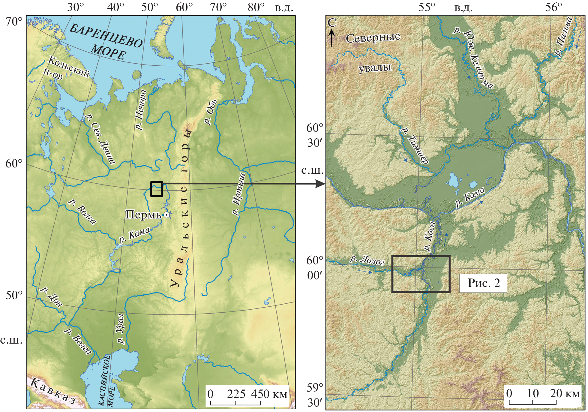
В качестве такого района может рассматриваться место слияния рек Лолог и Коса в северном Прикамье ( рис. 1 ), где первые люди появляются в раннем голоцене. Предыдущие исследования показали достаточно тесную связь между локальными природными обстановками и выбором стратегий расселения человеческих обществ в долине Верхней Камы в голоцене (Зарецкая и др., 2020; Лычагина и др., 2021).

Рис. 1. Карта расположения района исследований. Fig. 1 . Study area.
Целью настоящей статьи является реконструкция природной среды позднеледниковья и условий обитания древнего человека в раннем голоцене в нижнем течении р. Коса, на участке ее слияния с р. Лолог.
РАЙОН ИССЛЕДОВАНИЙ
Изучаемая территория расположена в правобережной части бассейна Верхней Камы, в долинах рр. Коса и Лолог ( рис. 1 ). Здесь находятся три мезолитические стоянки (Коса I, Коса II и Коса III), открытые во второй половине XX в. (рис. 2).

Рис. 2. Геоморфологическая карта района исследований. Пойма: 1 – низкая, 2 – высокая; надпойменная терраса: 3 – первая, 4 – вторая; 5 – контур заболоченной ложбины (палеорусла Лолога) и ее притоков на второй надпойменной террасе; 6 – расположение пробуренных скважин и радиоуглеродные даты; 7 – местоположение скважины Камской партии Всесоюзного гидрогеологического треста; 8 – археологические памятники (стоянки): 1 – Коса I, 2 – Коса II, 3 – Коса III; 9 – населенные пункты. Fig. 2 . Geomorphological map of the study area. 1 – low floodplain; 2 – high floodplain; 3 – 1st terrace; 4 – 2nd terrace; 5 – palaeochannels of Lolog and its tributaries on the 2nd terrace; 6 – location of boreholes and 14 C dates; 7 – location of deep-drilling boreholes; 8 – archaeological sites: 1 – Kosa I, 2 – Kosa II, 3 – Kosa III; 9 – settlements.
Река Коса – крупнейший правый приток Верхней Камы. Ширина русла в нижнем течении составляет 60–70 м, а после впадения р. Лолог – 110–120 м. Среднегодовой расход воды в Косе – 43.9 м 3 /с, в Лологе – 12.5 м 3 /с. Питание бассейна снеговое, что обусловливает высокие половодья, сменяющиеся относительно низкой меженью. При подъеме воды на 5 м над меженным урезом Лолога, в его устье начинается затопление поймы и заполнение стариц на правом берегу ( рис. 2 ).
Долины Косы и Лолога – широкие, состоят из поймы и надпойменных террас, сложенных легкоразмываемыми аллювиальными песками и суглинками, которые подстилаются песчаниками, глинами и мергелями пермского возраста. Вблизи русла встречаются ивовые и ольхово-березовые заросли с куртинами елей и сосен на возвышенных местах. Долины окружены слабохолмистыми водораздельными пространствами, покрытыми еловыми лесами. Правый борт долины Косы занят обширным грядово-мочажинным болотом Ыджиднюр. По высоте болото соответствует первой надпойменной террасе, но полностью лишенной следов гривистого флювиального рельефа. В пределах болота встречаются мелкие озера (Вад, Вадты, Ниж. Косинское, Маркош), вероятно, являющиеся остатками древнего палеоводоема.
Относительная высота первой надпойменной террасы 7–8 м над меженным урезом (над м. у.), второй – 17–19 м над м. у. Пойма представлена почти непрерывной полосой шириной 1–2 км вдоль Лолога и Косы, достигая максимального развития на участке их слияния ( рис. 2 ). Хорошо выделяются два уровня, отличающиеся как относительной высотой, так и характером растительности. Низкая пойма, изобилующая молодыми незаросшими старицами, имеет высоту 2–3 м над м. у., занята заливными лугами. Высокая пойма имеет относительную высоту 4–5 м над м. у. и покрыта, в основном, темнохвойным лесом. Для обоих уровней характерно развитие многочисленных изогнутых грив (валов), придающих пойме волнистый облик.
МЕТОДЫ ИССЛЕДОВАНИЙ
Для определения приуроченности археологических памятников к ландшафтам внутри речной долины было проведено их картографирование. Границы стоянок Коса II и III были уточнены в ходе шурфовки, осуществленной в 2018 г.
Раскопки стоянок Коса II и III проводились с трехмерной фиксацией всех находок, кроме мелких чешуек. Весь грунт просеивался на ситах с ячейкой 0.5 см. Слои земли снимались условными горизонтами параллельно дневной поверхности. Мощность горизонтов варьировалась от 0.05 до 0.1 м в зависимости от особенностей стратиграфии отдельного памятника. В тех случаях, когда на дне ям или каких-то построек фиксировался органогенный материал (уголь), он собирался для проведения радиоуглеродного анализа. На обоих памятниках были отобраны палинологические колонки.
Костные остатки определены с использованием эталонной коллекции скелетов музея Института экологии растений и животных УрО РАН. В настоящее время они хранятся в музее. Кости сильно фрагментированы и имеют размеры от 3 до 20 мм, поэтому определить до вида большинство костей не удалось. На основании толщины компакты костей, они были разделены на следующие размерные группы: размером с лося; размером с северного оленя; размером с лося – северного оленя; мелкие виды, размером с бобра и менее; неопределенные.
Палеорусловой анализ подразумевал изучение первичного рельефа и строения поймы и надпойменных террас. В результате определялись палеопараметры рек, такие, как водность и морфодинамические типы русла – его меандрирование и многорукавность (Чалов, 1996). Группы сегментов поймы, по которым можно восстановить положение русла, возникли на определенных этапах развития рек. В связи с этим они могут быть объединены в одновозрастные пойменные генерации. Для подтверждения предположений о возрасте генераций и верификации карты было проведено радиоуглеродное датирование образцов пойменных отложений, отобранных в наиболее характерных местах каждой генерации – со дна палеорусел и ложбин ( рис. 2, 3 ). Радиоуглеродный анализ был проведен в лаборатории геохимии изотопов и геохронологии Геологического института РАН (индекс ГИН) (по методике, описанной в Zaretskaya et al., 2012) и Институте истории материальной культуры РАН (Санкт-Петербург, индекс Ле). Все датировки были откалиброваны (перевод радиоуглеродного возраста в календарный) с помощью программы Calib 810 ( табл. 1 ) и калибровочной кривой IntCal 2020 (Reimer et al., 2020). Возраст образцов показывает время, когда активное русло начинало либо смещаться в сторону, либо отмирать.

Рис. 3. Строение разрезов (кернов скважин) заполнений палеорусел в окрестностях Косинских стоянок и результаты радиоуглеродного датирования. 1 – песок; 2 – суглинок; 3 – торф; 4 – торф суглинистый (суглинок оторфованный); 5 – сапропель; 6 – место отбора 14С образца; 7 – радиоуглеродные даты (некалиброванные (л. н.) и калиброванные (кал. л. н.). Fig. 3 . The structure of sections (boreholes) of palaeochannel fillings in the vicinity of the Kosinsky sites and the results of radiocarbon dating. 1 – sand; 2 – silt; 3 – peat; 4 – silty peat (peaty silt); 5 – gyttja; 6 – 14 C sampling sites; 7 – radiocarbon dates.
Таблица 1. Описание разрезов (скважин), заложенных в пределах палеорусел в окрестностях Косинских стоянок, и результаты радиоуглеродного датирования. Table 1. Description of the boreholes within the palaeochannels in the neighborhood of the Kosa archaeological sites, and the results of radiocarbon dating
Номер скважины | Строение разреза (скважины) | Индекс и номер | 14С дата, л. н. | Калиброванный возраст, л. н. | Координаты | Абс. высота устьев скважин, м |
1028 (у стоянки Коса I) | 0-2.95 м - торф буро-коричневый 2.95— 3.02 м — торф бурый суглинистый 3.1— —3.2 м — переслаивание суглинка легкого опесчаненного и песка м/з-с/з буровато-серого 3.2— 3.25 м — песок с/з серый, хорошо отмытый 3.25— 3.32 м — суглинок оторфованный 3.38— 3.89 м — торф суглинистый, книзу переходящий в торф (14С: 3.75-3.9 м) 3.89— 4.0 м — песок серый с/з — к/з, хорошо отмытый | ГИН-15880 | 9350 ± 50 | 10600-10500 | 59.978971° 55.035509° | 135 |
1030 (у стоянки Коса II) | 0—2.3 м — торф буро-темно-коричневый, плотный (14С: 2.2—2.3 м) 2.3—2.6 м — суглинок сизо-серый, тяжелый 2.6—2.95 м — песок м/з серый хорошо отмытый | ГИН-15881 | 7075 ± 40 | 7960-7860 | 59.980256° 55.029992° | 135 |
1034 (у стоянки Коса III) | 0—2.05 м — торф темно-коричневый, плотный 2.05—2.35 м — торф бурый (14С: 2.25—2.35 м) 2.35—2.75 м — сг буровато-сизый 2.75—3.0 м — песок серый м/з | ГИН-15884 | 7100 ± 50 | 7975-7860 | 59.981931° 55.039249° | 137 |
1035 (болото Ыджиднюр) | 0—4.03 м — торф коричневый 4.03—4.17 м — торф суглинистый коричневый, понизу бурый сапропель (14С: 4.03—4.17 м) 4.17—4.25 м — песок м/з, сверху суглинистый, серый | ГИН-15885 | 8750 ± 40 | 9785-9660 | 59.960059° 55.141809° | 137 |
1036(палеорусло Лолога) | 0—3.7 м — торф коричневый 3.7—4.2 м — сапропель бежевый зернистый, очень плотный, сухой (14С: 4.05—4.15 м) 4.2—4.34 м — торф суглинистый 4.34—4.4 м — песок серый оглиненный | ГИН-15886 | 11900 ± 60 | 13650-13800 | 59.968608° 55.017849° | 133 |
Стоянка Коса II | Яма 4, гл. —0.6—0.75 м, уголь | Ле-12162 | 6870 ± 180 | 7860-7575 | 59.979617° 55.030161° | 137 |
Для реконструкции растительности и климата, отражающих условия, в которых существовали поселения древних людей, проведены палинологические и палеокарпологические исследования. Материалы для изучения отбирались с помощью ручного бурения из заполнений ложбин и палеорусел ( табл. 1 ; рис. 2, 3 ).
Образцы для спорово-пыльцевого анализа обрабатывали щелочным методом Поста (Пыльцевой анализ, 1950). Палиноостатки определены во временных глицериновых препаратах с помощью микроскопа Olympus BX51 при увеличении в 400 раз. Для анализа была использована эталонная коллекция современной пыльцы и спор музея ИЭРиЖ УрО РАН, а также атлас-определитель H-J. Beug (2004). Подсчитано 513–939 пыльцевых зерен наземных растений, при параллельной регистрации спор высших споровых растений и устьиц хвойных растений. Обработка данных и построение диаграммы выполнялись в программе Tilia v. 2.0.41. (Grimm, 2004). Доля пыльцы таксонов деревьев и кустарников, кустарничков и трав, а также спор высших споровых растений, была рассчитана от общей суммы пыльцы древесных и травянистых растений (принята за 100% и представлена на спорово-пыльцевой диаграмме).
Обработка палеокарпологических проб проводилась в лабораторных условиях на почвенных ситах с диаметром ячейки 0.25 мм, в соответствии со стандартными методиками (Никитин, 1969). Объем исследуемых проб составлял в среднем 100 мл. В большинстве случаев остатки имеют хорошую сохранность. Идентификация растительных макроостатков основана на анализе коллекции музея ИЭРиЖ УрО РАН.
РЕЗУЛЬТАТЫ ИССЛЕДОВАНИЙ
Археологический исследования
Косинские стоянки (Коса I–III) были открыты в 1962 г. в ходе разведки В.П. Денисова. В августе того же года им были проведены раскопки на стоянке Коса I. Памятник расположен на краю второй надпойменной террасы, поверхность которой возвышается над заболоченным палеоруслом не более чем на 6–7 м ( рис. 2 ). Была вскрыта площадь 376 м 2 (Денисов, 1962). Вещевой материал представлен исключительно кремневым и каменным инвентарем (2927 предметов), среди которых 168 экземпляров орудий. Дополнительно был собран и проанализирован остеологический материал, представленный фрагментами кальцинированных костей животных. На памятнике были изучены остатки легкого сезонного углубленного сооружения прямоугольной формы с закругленными углами размером 4.8 × 2.4 м. Каменный инвентарь стоянки, по мнению авторов раскопок, отражает заключительный этап развития мезолита в Верхнем Прикамье (Денисов, Мельничук, 1987, с. 24–25). Стоянки Коса II и III в то время исследовались только с помощью шурфов на незначительной площади.
Археологические раскопки на стоянке Коса II проводились в период с 2018 по 2021 г. Памятник расположен на пологонаклонном уступе второй надпойменной террасы. Поверхность стоянки возвышается над заболоченной ложбиной не более чем на 4 м ( рис. 2 ). В результате работ изучено 65 м 2 территории памятника. Коллекция находок состоит из 3515 предметов.
Авторами раскопок были выделены следующие слои:
1 слой – дерн, мощностью в среднем 0.03 м, примерно одинаков на всей изученной территории;
2 слой – светло-серый подзол, мощностью в среднем 0.15 м, с локальными заглублениями в местах корневых систем деревьев;
3 слой – темно-коричневая увлажненная супесь с вкраплениями ортзандов (культурный слой), мощность варьируется от 0 до 0.3 м (в среднем 0.16 м.);
4 слой – желто-оранжевый мелкий сыпучий песок с ортзандами (материк);
5 слой – влажная желтая супесь с углистыми прослойками (культурный слой). Представляет собой заполнение ям, происхождение которых мы связываем с существованием мезолитического населения. Средняя мощность слоя 0.23 м.
Основная масса находок приурочена к условным горизонтам № 1 – № 4 (0.1–0.25 м от дневной поверхности) и располагалась в нижней части светло-серого подзола и в слое темно-коричневой увлажненной супеси.
Каменный инвентарь похож на материалы со стоянки Коса I, что проявляется в используемом сырье, наличии больших групп отщепов и средних пластин, идентичных формах орудий. Остеологическая коллекция, полученная в ходе раскопок, состоит из фрагментов кальцинированных костей млекопитающих и рыб.
В 2018 г. на памятнике из стенки шурфа была отобрана колонка образцов для спорово-пыльцевого анализа ( рис. 4 ). Были получены довольно однообразные спорово-пыльцевые спектры, характеризующиеся обилием пыльцы сосны ( Pinus sylvestris -type) при участии ели ( Picea ) и березы ( Betula sect. Albae ). Они характеризуют сообщества таежных лесов с преобладанием в древостое сосны и участием ели и березы, как до появления древнего человека, так и во время функционирования стоянки. Спорово-пыльцевой спектр с обилием пыльцы ивы ( Salix ) в нижней части “культурного слоя” может указывать на использование ивы в хозяйственной деятельности человека. В частности, она могла применяться для изготовления вершей или плетения корзин. В спектрах “культурного слоя” встречены пыльцевые зерна иван-чая ( Chamaenerion angustifolium ), который является индикатором пирогенных растительных сообществ, а также мелкие частицы угля (Демаков и др., 2019).

Рис. 4. Спорово-пыльцевая диаграмма культуросодержащих и подстилающих отложений стоянки Коса II. 1 – песок “подзол”; 2 – супесь “культурный слой”; 3 – песок “материк”. Fig. 4 . Pollen diagram of the culture-bearing and underlying sediments of the Kosa II site. 1 – sand “podzol”; 2 – sandy loam “cultural layer”; 3 – sand “sterile layer”.
В 2019 г. был проведен петрографический анализ каменного сырья со стоянки Коса II. Он позволил выяснить, что основным материалом для изготовления орудий служила окремненная яшма вулканогенно-осадочного происхождения. Из этого материала изготовлено более 75% изделий. Источники яшмы в окрестностях стоянок не известны. Вторая группа представлена разными по составу кремнями. К этой группе относится около 20% находок (Демаков и др., 2020, с. 30–31).
В 2020 г. по образцу угля из заполнения ямы № 4, насыщенной находками, была получена датировка 7860–7575 кал. л.н. (6870 ± 180 л. н., Ле-12162). Яма располагалась под современной грунтовой дорогой. Культурные напластования памятника представляют собой супеси различных оттенков. Мы не исключаем то, что в результате современного антропогенного воздействия, а также деятельности корневой системы деревьев в образец мог попасть более молодой органогенный материал. Таким образом, данная датировка не может считаться валидной ( табл. 1 ).
В 2021 г. были начаты археологические раскопки на стоянке Коса III. Памятник расположен на первой надпойменной террасе, имеющей гривистый характер рельефа ( рис. 2 ). На данный момент изучено 24 м 2 площади памятника. Коллекция находок состоит из 1511 предметов.
Строение разреза следующее:
1 слой – дерн, мощностью в среднем 0.04 м, примерно одинаков на всей площади раскопа;
2 слой – светло-серый подзол, мощностью в среднем 0.2–0.25 м;
3 слой – темно-коричневая увлажненная супесь с вкраплениями ортзандов (культурный слой). В пределах раскопа его мощность варьировалась, но в среднем достигала 0.15 м;
4 слой – перемешанные слои темно-серой плотной супеси, представляющие собой колею дороги;
5 слой – желто-оранжевый мелкий сыпучий песок с ортзандами (материк).
Максимальная концентрация находок приходилась на глубину 0.15–0.35 м от дневной поверхности. В основном они приурочены к нижней части слоя, представленного светло-серым подзолом и темно-коричневой увлажненной супесью с вкраплениями ортзандов.
Каменный инвентарь отличается от материалов стоянок Коса I и II. Различие наблюдается в используемом сырье (в основном это галечниковый кремень, яшма практически не встречается), а также наличии большой группы первичных сколов и отсутствии широких пластин. Остеологическая коллекция состоит из фрагментов кальцинированных костей млекопитающих. Проведенные на современном методическом уровне исследования подтвердили мнение В.П. Денисова о том, что этот памятник (Коса III) несколько моложе, чем стоянки Коса I и Коса II (Денисов, 1962).
Остеологический анализ
В культурных слоях стоянок Коса I–III найдены костные остатки животных (Коса I – 197 фрагментов, Коса II – 375 фрагментов, Коса III – 39 фрагментов). Все они являются кальцинированными, т.е. испытавшими длительное воздействие высокой температуры, благодаря чему сохранились. Большинство остатков животных принадлежат парнокопытным млекопитающим (552 фрагментов из 611). Костные остатки других млекопитающих представлены единичными экземплярами. Отдельную группу (37 фрагментов) составляют остатки рыб.
На всех стоянках основным занятием населения была охота на копытных (лось, северный олень). Определенную роль играла охота на бобра. Рыболовство отмечено только на Косе II, но, вероятно, им занималось в разной степени население всех стоянок. Эту информацию можно подтвердить только в ходе дальнейших исследований.
Видовой состав фауны указывает на существование стоянок в таежной зоне (Животный мир СССР, 1953). Находка остатков судака совпадает с северной границей его современного ареала (Попова, 1998). Судак является относительно теплолюбивым видом, поэтому во время функционирования стоянки Коса II среднегодовые температуры были не ниже современных ( рис. 5 ).

Рис. 5. Результаты остеологического анализа. Знак вопроса означает, что кости принадлежат животному, сравнимому по размерам с указанным. Fig. 5 . The results of osteological analysis. The question mark means that the bones belong to an animal comparable in size to the one indicated.
Палеорусловые исследования
В районе слияния Косы и Лолога выделяется “слепая” заболоченная ложбина, которая вытянута в субширотном направлении в 2 км южнее современного русла р. Лолог и заканчивается в 4 км выше его устья ( рис. 2 ). В нее открываются руслоподобные образования меньших размеров, по-видимому, малые притоки древнего Лолога. Ориентировка ложбины, вероятно, указывает на то, что она является палеоруслом самого Лолога, а ее ширина (350–370 м) может указывать на ширину пояса меандрирования водотока. Аналогичные формы рельефа повсеместно встречаются и в левобережной части бассейна Верхней Камы, на междуречьях Тимшера, Южной Кельтмы и Пильвы (Назаров и др., 2020).
О глубине и характере вреза палеорусла можно судить на основании скважины 520, пробуренной Камской партией Всесоюзного гидрогеологического треста, проводившей изыскания под строительство Верхнекамского водохранилища в 1959 г. (Зилинг и др., 1960) ( рис. 2 ). Под мощным слоем песка, который книзу становится более кварцевым, на глубине 14.7 м вскрыта гравийно-галечниковая толща (ее мощность 1.1 м.). Отложения представляют собой русловую фацию аллювия – переслаивание серого, кварцевого среднезернистого песка и хорошо окатанной гальки размером до 4 см, состоящей из кварца, кварцевого песчаника. На глубине 16.1 м вскрыт слой темно-красной пермской глины с большим количеством щебенки выветрелого известняка.
Около 13 800–13 500 кал. л. н. (11900 ± 60 л. н., ГИН-15886) территория правобережья Верхней Камы предположительно была более увлажненной, чем в последующие периоды позднеледниковья и голоцена (время активных перестроек гидросети). Протекающие по этой территории реки формировали широкие долины, которые в настоящее время запечатлены в рельефе и отложениях второй надпойменной террасы (Назаров, Копытов, 2020). Ширина долины пра-Косы составляла 2.6–3 км (в настоящее время 1–2 км). Перигляциальные условия, сильные ветры, переносившие песок, обусловили наличие мощной эоловой толщи отложений на поверхности второй террасы и появление на ней дюн. В пределах дюн сформировались ландшафты сухих сосновых боров-зеленомошников.
В позднем дриасе в системе Коса–Лолог произошла перестройка речной сети: Лолог оставил прямую ложбину, соединявшую его с Косой по кратчайшему расстоянию, и отклонился влево – на север, обтекая оставленный рекой останец второй террасы. Ее поверхность приобрела весьма комфортные условия для существования и жизнедеятельности человека. Возраст торфа на кровле хорошо отмытого среднезернистого песка, вскрытого скважиной 1028 на глубине 3.8 м, соотносится с началом голоцена – временем функционирования русла Лолога возле стоянок Коса I и Коса II ( табл. 1 ).
Доступ к воде был обеспечен ручьями, по которым еще происходил сток воды, а также относительной близостью русел рек – Лолога на севере и Косы на востоке, которые в то время формировали первую террасу. Относительная высота опесчаненного бора второй террасы над меженым уровнем этих рек в то время составляла 7–8 м.
Поздний дриас и ранний голоцен характеризовались переходом от квазиперигляциального климата – прохладного с возможным распространением еще нерастаявшей вечной мерзлоты, к относительно теплому климату раннего атлантического периода. В это время рр. Коса и Лолог формировали поверхность современной первой надпойменной террасы. Возраст отложений, вскрытых скважиной 1034, составил 7980–7860 кал. л. н. (7100 ± 50 л. н., ГИН-15884) ( рис. 2 ). Стоит отметить, что возраст террас на Лологе и Косе несколько моложе возраста первой надпойменной террасы на р. Каме (около 8800–11 000 кал. л. н.). В связи с небольшой активностью горизонтальных русловых деформаций Косы и Лолога, в поверхность первой террасы были включены более молодые участки. При картографировании днища долины Камы подобные геоморфологические элементы относились к пойменно-террасовой поверхности (7-й пойменной генерации) (Лычагина и др., 2021).
Во время формирования первой надпойменной террасы русла обеих рек интенсивно меандрировали – следы их блужданий хорошо выражены в первичном пойменном рельефе. Размеры излучин обеих рек, формировавшихся в раннем голоцене, превышают параметры современных меандров. Так, радиусы кривизны палеоизлучин Лолога составляют 400 м, при этом современные значения не превышают в среднем 150 м. На р. Косе радиусы кривизны стариц на террасе равны приблизительно 300 м, а излучины современного русла изогнуты на величину 200 м. На основании полученных данных можно сказать, что в раннем голоцене водность Лолога была выше Косы. На протяжении голоцена эта разница стала снижаться, потом полностью исчезла. Об этом свидетельствуют параметры современных излучин, расположенных в пределах поймы. Водность Лолога снизилась.
Миграции русел Лолога и Косы в северном и восточном направлениях заставили мезолитического человека переместить место своего обитания примерно на 500 м к северо-востоку от предыдущего (Коса III, стоянка). Теперь русло Косы стало находиться от новой стоянки в 400 м к востоку. Местоположение этой стоянки было выбрано на невысокой песчаной дюне, осложняющей поверхность первой надпойменной террасы р. Косы.
В среднем и позднем голоцене на обеих реках стала активно образовываться пойма. На Косе и Лологе активизировались русловые деформации на фоне периодически возрастающей водности. У обеих рек увеличивался пояс меандрирования, стало более интенсивным образование новых переувлажненных пойменных массивов, осложненных многочисленными ложбинами и старицами ( рис. 2 ).
Спорово-пыльцевой и палеокарпологический анализы
Спорово-пыльцевой спектр для интервала 13 800–13 500 кал. л. н. (11 900 ± 60 л. н., ГИН-15 886) ( рис. 3 ) ( табл. 1 ) по преобладанию пыльцы кустарничков и травянистых растений (86%) и соотношению ксерофитных ( Artemisia sp., Poaceae и Chenopodiaceae и др.), бореальных ( Larix , Picea , Pinus sylvestris -type, Betula sect. Albae ) и аркто-бореальных ( Betula sect. Nanae , Ericaceae) таксонов характеризует растительные сообщества ландшафтов перигляциального облика, типичные для позднеледниковья ( рис. 6 (а)). Травяной покров пойменных и суходольных лугов формировали виды осок (Cyperaceae – около 80%) и злаков (Poaceae) при участии верескоцветных кустарничков (Ericaceae) и разнотравья. На незадернованных субстратах встречались полыни ( Artemisia ) и виды маревых (Chenopodiaceae). Кустарниковые заросли формировали березы Betula sect. Nanae . Могли произрастать единичные лиственницы ( Larix ) и, возможно, ели ( Picea ). Аналогичные позднеледниковые перигляциальные растительные сообщества реконструированы для территории бассейна р. Вычегды и ее притоков, находящейся севернее района исследования (Голубева, 2010; Андреичева и др., 2015).

Рис. 6. Результаты спорово-пыльцевого и палеокарпологического анализов. Сводные спорово-пыльцевая диаграмма (а) и карпограмма (б) Косинских скважин. Fig. 6 . Results of pollen and carpological analyses. Summary pollen diagram (а) and summary carpologic diagram (б) of Kosa boreholes.
Данные по макроостаткам растений показали, что в ландшафте преобладали кустарниковые березы Betula humilis . Встречались относительно холодолюбивые виды: плаунок Selaginella selaginoides и эндемичный для Урала Potamogeton sibiricus (Флора Сибири, 1988; Поспелова, Поспелов, 2007). Была развита растительность мелководной зоны из Hippuris vulgaris и Sparganium . Среди околоводных видов доминируют осоки Carex , а также Eleocharis palustris и Ranunculus gmelinii , что указывает на существование отмелей. В условиях холодного климата позднеледниковья здесь находился водоем с низкорослой околоводной растительностью и зарослями из кустарниковых берез по берегам ( рис. 6, (б)).
Спорово-пыльцевой спектр для интервала 10 600–10 500 кал. л. н. (9350 ± 50 л. н., ГИН-15880) ( рис. 3 ) ( табл. 1 ), соответствующего пребореальному периоду голоцена, отражает лесной тип растительности по преобладанию пыльцы древесных пород – 87% ( рис. 6 , (а)). Были распространены светлохвойно-мелколиственные леса, в древостое которых доминировали сосна ( Pinus sylvestris -type – более 50%) и береза ( Betula sect. Albae – около 20%) при участии лиственницы и ели. В подлеске встречалась кустарниковая береза. Травяной покров формировали виды осок, злаков и разнотравья. В это же время на междуречье рек Вятки и Камы в древостое лесов доминировали сосна и береза, ель играла второстепенную роль, а в подлеске встречались кустарниковые березки (Прокашев и др., 2003).
Макроостатки растений (рдест Potamogeton praelongus , кувшинка Nymphaea аlba , кубышка Nuphar ) характеризуют условия относительно глубокого палеоводоема или серии озер (вероятно, остатков мигрировавшего к северу русла Лолога). В окрестностях водоема рос березовый лес с участием ели и сосны. Видовой состав палеофлоры аналогичен современной растительности, что позволяет предполагать наличие здесь сходных климатических условий ( рис. 6, (б)).
В спорово-пыльцевом спектре для интервала 9785–9660 кал. л. н. (8750 ± 40 л. н., ГИН-15885) ( рис. 3 ) ( табл. 1 ), соответствующего бореальному периоду голоцена, преобладает пыльца древесных пород (85%), что характеризует доминирование лесного типа растительности ( рис. 6, (а)). Были распространены таежные леса с преобладанием сосново-березовых формаций при участии ели. Кустарниковые березы встречались в подлеске. Обилие пыльцы березы может отражать распространение вторичных березовых лесов на гарях. Данное обстоятельство косвенно подтверждает и присутствие пыльцы иван-чая ( Chamaenerion angustifolium ), являющегося пионерным видом пирогенных растительных сообществ. В бореальном периоде на территории Вятско-Камского междуречья были распространены сосново-березовые леса со значительным участием кустарниковых берез и небольшим участием ели (Прокашев и др., 2003). На территории междуречья рек Камы и Вычегды были распространены леса, древостой которых формировали, преимущественно, сосна и ель при участии березы (Андреичева и др., 2015).
Комплекс растительных макроостатков состоит из осок Carex , среди которых много обугленных семян (33 экземпляра). Остатки водного вида Myriophyllum verticillatum единичны. Скорее всего, такой обедненный состав палеофлоры связан с прошедшим пожаром. В связи с этим реконструировать растительные сообщества затруднительно. В пробе, отобранной выше датированного слоя, также найдены обугленные макроостатки осок и хвоя ели ( рис. 6, (б)).
Спорово-пыльцевой спектр для интервала 7980–7860 кал. л. н. (7100 ± 50 л. н., ГИН-15884) ( рис. 3 ) ( табл. 1 ), соответствующего атлантическому периоду, отражает лесной тип растительности с доминированием пыльцы древесных пород (93%). Наряду с березово-сосновыми лесами начали формироваться еловые леса (доля пыльцы Picea возросла до 20% при практически равном содержании Betula sect. Albae и Pinus sylvestris -type ( рис. 6, ( а)). В единичном количестве появились пыльцевые зерна ольхи ( Alnus sp.) и вяза ( Ulmus sp.). Примерно с этого времени в поймах рек Верхнего Прикамья начали распространяться вяз и ольха (Лычагина и др., 2021). На междуречье Камы и Вятки в первой половине атлантического периода продолжали доминировать сосна и береза, в то же время стали распространяться еловые формации. Как и прежде, в подлеске встречались кустарниковые березки. Появились широколиственные породы в лесах (Прокашев и др., 2003). В бассейне р. Вычегды и ее притоков также в хвойных лесах встречались широколиственные породы (Андреичева и др., 2015).
Данные по макроостаткам растений показывают, что на изученной территории в этот период еще существовали остаточные озера с медленно текущей или стоячей водой (появляются ряска Lemna и болотные виды). В окрестностях водоема произрастал смешанный хвойно-березовый лес ( рис. 6 , (б)).
ОБСУЖДЕНИЕ РЕЗУЛЬТАТОВ
На основе результатов исследований были выделены три хронологических этапа, связанных с изменением палеогеографических условий в районе исследования.
Первый этап связан с позднеледниковьем. Для него характерен достаточно холодный климат, высокая влажность, распространение перигляциальных ландшафтов, отсутствие леса как естественной защиты от сильного ветра, а также места обитания крупных копытных (лосей). Вторая надпойменная терраса находилась в стадии формирования и не могла рассматриваться как удобное место даже для кратковременной стоянки на берегу водоема с низкорослой околоводной растительностью. Все эти условия являлись неблагоприятными для проживания человека. Это подтверждается тем фактом, что в окрестностях Верхней Камы, севернее, а также на широте района исследований, отсутствуют палеолитические памятники. Ближайшие стоянки финального палеолита (Усть-Пожва I-V) находятся на правом берегу Камы, в 100 км к югу от места слияния Косы и Лолога (Мельничук, 2007, с. 7).
Следующий этап относится уже к раннему голоцену (пребореальный и бореальный периоды). В это время, из-за перестройки русла р. Лолог, окончательно сформировалась поверхность второй террасы. Она приобрела комфортный для освоения человеком облик, возвышаясь над меженным уровнем Лолога и Косы на 7–8 м. Поверхность террасы была покрыта таежными сосновыми и березовыми лесами с участием ели. Данные палеокарпологического анализа указывают на наличие здесь глубоких остаточных озер.
Мы предполагаем, что все вышеперечисленные условия привели к тому, что в финале данного периода на краю второй надпойменной террасы возникли стоянки Коса I и II (расположенные друг от друга на расстоянии 120 м) ( рис. 2 ). Вероятно, они отражают жизнь одного мезолитического коллектива, который занимался охотой на копытных в местных таежных лесах, а также рыболовством в озерах, находившихся в непосредственной близости от стоянок. Временная углубленная сезонная постройка, обнаруженная при раскопках стоянки Коса I (Денисов, Мельничук, 1987, с. 20, рис. 1 ), а также следы рыболовства со стоянки Коса II, вероятно, маркируют возникновение частичной оседлости у местного населения.
Заключительный хронологический этап соотносится с ранним атлантическим периодом. Потепление климата и активное меандрирование Лолога и Косы привели к формированию поверхности, которая при последующем врезании обеих рек стала первой надпойменной террасой. Основные русла Лолога и Косы сместились на север и восток от района исследований, а здесь какое-то время сохранялся палеоводоем с медленнотекущей или стоячей водой. В существовавших мелколиственно-светлохвойных лесах возросла роль ели, вероятно, появился вяз. Миграции русел Лолога и Косы привели к тому, что человек вынужден был осваивать невысокую песчаную дюну, которая сформировалась на поверхности первой надпойменной террасы р. Косы. Таким образом, возникла стоянка Коса III. Население стоянки занималось охотой на копытных, возможно, рыболовством, по аналогии со стоянками Коса I и II.
Во второй половине среднего голоцена эти места перестали рассматриваться людьми как удобные даже для кратковременного проживания из-за отдаленности основных русел рек, а также периодически возрастающей водности, которая приводила к переувлажненности поймы и первой террасы. Переход сначала к частичной, а затем и полной оседлости в развитом неолите – энеолите (о чем говорит появление долговременных жилищ-полуземлянок) диктовал новую стратегию в выборе локаций для проживания. В качестве таких участков рассматривались первые надпойменные террасы крупных рек, которые не затапливались в половодье, а также берега старичных озер (Зарецкая и др., 2020; Лычагина и др., 2021).
ЗАКЛЮЧЕНИЕ
В ходе исследования было установлено, что условия, благоприятные для освоения человеком данного региона, сложились в пребореальный – бореальный периоды голоцена, когда были распространены сосново-березовые леса, богатые дичью. В это время на месте будущей первой надпойменной террасы существовала серия довольно крупных остаточных озер. Сухая и достаточно высокая вторая терраса, не затапливаемая в паводок, являлась удобным местом для стоянок древнего человека. Индивидуальная охота на крупных копытных и бобра была основным промысловым занятием населения. Рыболовство имело вспомогательное значение.
В начале атлантического периода условия для ведения присваивающего хозяйства, в целом, оставались благоприятными, хотя снижение уровня воды в обеих реках в межень привело к постепенному уменьшению, осушению и заторфовыванию водоемов. Возможно, в это время охота на лося и северного оленя играла еще более значимую роль, чем рыболовство.
В дальнейшем, из-за смещения русел Косы и Лолога к востоку и формирования переувлажненных пойм, человек покинул эти места.
Вновь люди появились в окрестностях с. Коса только в эпоху Великого переселения народов. В то время они осваивали или коренные берега рек, или долины небольших рек и ручьев. Такая же ситуация сохранялась и в средневековье.
БЛАГОДАРНОСТИ
Исследование выполнено при поддержке Министерства образования и науки Пермского края, соглашение № С-26/1192 от 19.12.2019 г.; в рамках государственных заданий: ИГ РАН (FMWS-2019-0008); ИЭРиЖ УрО РАН (№ 122021000095-0). Геоморфологическое картографирование выполнено при поддержке гранта №ГСГК-0076/21, проект реализовывался победителем конкурса на предоставление грантов преподавателям магистратуры 2020/2021 благотворительной программы “Стипендиальная программа Владимира Потанина” Благотворительного фонда Владимира Потанина.
About the authors
D. A. Demakov
Perm State Humanitarian Pedagogical University
Author for correspondence.
Email: demakov-denis@mail.ru
SPIN-code: 8351-8408
аспирант кафедры Отечественной и всеобщей истории, археологии
Russian Federation, PermE. L. Lychagina
Perm State Humanitarian Pedagogical University; Perm State University
Email: demakov-denis@mail.ru
Russian Federation, Perm; Perm
N. E. Zaretskaya
Institute of Geography, RAS; Geological Institute, RAS
Email: demakov-denis@mail.ru
Russian Federation, Moscow; Moscow
S. V. Kopytov
Perm State University
Email: demakov-denis@mail.ru
Russian Federation, Perm
A. V. Chernov
Lomonosov Moscow State University; Moscow Pedagogical State University
Email: demakov-denis@mail.ru
Russian Federation, Moscow; Moscow
E. G. Lapteva
Institute of Plant and Animal Ecology Urals Branch of the RAS
Email: demakov-denis@mail.ru
Russian Federation, Yekaterinburg
S. S. Trofimova
Institute of Plant and Animal Ecology Urals Branch of the RAS
Email: demakov-denis@mail.ru
Russian Federation, Yekaterinburg
P. A. Kosintsev
Institute of Plant and Animal Ecology Urals Branch of the RAS
Email: demakov-denis@mail.ru
Russian Federation, Yekaterinburg
References
- Andreicheva L.N., Marchenko-Vagapova T.I., Buravskaya M.N., and Golubeva Yu.V. Prirodnaya sreda neopleistotsena i golotsena na Evropeiskom Severo-Vostoke Rossii (The natural environment of the Neo-Pleistocene and Holocene in the European Northeast of Russia). Moscow: GEOS (Publ.), 2015. 224 p. (in Russ.)
- Beug H-J. Leitfaden der Pollen bestimmung für Mitteleuropa and angrenzende Gebiete. München: Verlag Friedrich Pfeil (Publ.), 2004. 542 p.
- Chalov R.S. Historical and paleorusology: subject, research methods and role in the study of relief. Geomorfologiya. 1996. No. 4. P. 13-18. (in Russ.)
- Chlachula J. Chronology and environments of the Pleistocene peopling of North Asia. Archaeological Research in Asia. 2017. Vol. 12. P. 33-53. https://doi.org/10.1016/j.ara.2017.07.006
- Demakov D.A., Lychagina E.L., and Kulkova M.A. The first results of petrographic analysis of stone raw materials from the Mesolithic site of Kosa II. Trudy Kamskoi arkheologo-etnograficheskoi ekspeditsii. Issue XVII. Perm. 2020. P. 27-32. (in Russ.) https://doi.org/10.24412/2658-7637-2020-17-27-32
- Demakov D.A., Lychagina E.L., and Lapteva E.G. First results of digging at the mesolithic site Kosa II. Trudy Kamskoi arkheologo-etnograficheskoi ekspeditsii. Issue XV. Perm. 2019. P. 4-10. (in Russ.) https://doi.org/10.24411/2658-7637-2019-11501
- Denisov V.P. Otchet ob arkheologicheskikh raskopkakh i razvedkakh, provedennykh Kosinskim otryadom VerkhneKamskoi arkheologicheskoi ekspeditsii Permskogo gosudarstvennogo universiteta i Komi-Permyatskim okruzhnym kraevedcheskim muzeem v iyune-avguste 1962 g. (Report on archaeological excavations and explorations conducted by the Kosinsky detachment of the Upper Kama Archaeological Expedition of Perm State University and the Komi-Permyak Regional Museum of Local Lore in June-August 1962). Arkhiv Instituta arkheologii Rossiiskoi akademii nauk (Archive of the Institute of Archaeology of the Russian Academy of Sciences). Soll. R-1. No. 2478. 46 p. (in Russ.)
- Denisov V.P. and Melnichuk A.F. Kosinskaya I, late mesolithic site - site in the Kama region. Problemy izucheniya drevnei istorii Udmurtii. 1987. P. 19-25. (in Russ.)
- Golubeva Yu.V. Paleogeografiya i paleoklimat pozdnelednikovʼya i golotsena v severnoi i srednei podzonakh taiga Timano-Pechorsko-Vychegodskogo regiona (po palinologicheskim dannym) (Paleogeography and paleoclimates of the Late Glacial and Holocene in the Northern and Middle taiga subzones of the Timan-PechoraVychegod region (according to palynological data). PhD thesis. Syktyvkar. 2010. 20 p. (in Russ.)
- Grimm E. Tilia software 2.0.2. Springfield, Illinois State Museum Research and Collection Center, 2004.
- Krasnoborov I.M. (Eds.). Flora Sibiri (Flora of Siberia). Novosibirsk: Nauka. Sib. Department (Publ.), 1988. 200 p. (in Russ.)
- Lychagina E.L., Demakov D.A., Chernov A.V., Zaretskaya N.E., Kopytov S.V., Lapteva E.G., and Trofimova S.S. Human palaeoenvironment in the Upper Kama river basin: experience of reconstruction. Vestnik arkheologii, antropologii i etnografii. 2021. No. 1 (52). P. 5-19. (in Russ.) https://doi.org/10.20874/2071-0437-2021-52-1-1
- Melnichuk A.F. Finalʼnyi paleolit Permskogo Priural’ya (The Final Paleolithic of the Permian Urals). PhD thesis. Izhevsk. 2007. 23 p. (in Russ.)
- Nazarov N.N. and Kopytov S.V. Stages of River Network Formationof the Upper Kama River Basin in the Pleistocene. Uchenye zapiski Kazanskogo universiteta. Seriya: Estestvennye nauki. 2020. Vol. 162. No. 1. P. 180-200. (in Russ.) https://doi.org/10.26907/2542-064X.2020.1.180-200
- Nazarov N.N., Kopytov S.V., Zhuikova I.A., and Chernov A.V. Pleistocene runoff channels in the southern part of the Keltma hollow (Kama-Vychegda watershed). Geomorfologiya. 2020. No. 4. P. 74-88. (in Russ.). https://doi.org/10.31857/S0435428120040070
- Nikitin V.P. Paleokarpologicheskii metod (Paleocarpological method). Tomsk: TSU (Publ.), 1969. 82 p. (in Russ.)
- Pavlovskii E.N., Vinogradov B.S., Arnoldi V.M., and Novikov G.A. (Eds.). Zhivotnyi mir SSSR (Animal world of the USSR). Moscow; Leningrad: Academy of Sciences of the USSR (Publ.), 1953. Vol. 4. Forest zone. 740 p. (in Russ.)
- Pokrovskaya I.M. (Eds.). Pylʼtsevoi analiz (Pollen analysis). M.: Gosgeolitizdat (Publ.), 1950. 553 p. (in Russ.)
- Popova O.A. Family Percidae Cuvier, 1816 - Perch. Annotirovannyi katalog kruglorotykh i ryb kontinentalʼnykh vod Rossii. 1998. P. 117-120. (in Russ.)
- Pospelova E.B. and Pospelov I.N. Flora sosudistykh rastenii Taimyra i sopredelʼnykh territorii. Ch. 1. (Flora of vascular plants of Taimyr and adjacent territories. Part 1). M.: Association of Scientific publications of the CMC (Publ.), 2007. 457 p. (in Russ.)
- Prokashev A.M., Zhuikova I.A., and Pakhomov M.M. Istoriya pochvenno-rastitelʼnogo pokrova Vyatsko-Kamskogo kraya v poslelednikovʼe (The history of the soil and vegetation cover of the Vyatka-Kama region in the post-glacial period). Kirov: VyatGGU (Publ.), 2003. 143 p. (in Russ.)
- Reimer P.J., Austin W.E.N., Bard E., Bayliss A., Beck J.W., Blackwell P.G., Bronk, Ramsey C., Butzin M., Cheng H., Edward, R.L., Friedrich M., Grootes P. M., Guilderson T.P., Hajdas I., Heaton T.J., Hogg A.G., Hughen K.A., Kromer B., Manning S.W., Muscheler R., Palmer J.G., Pearson C., Reimer R.W., Richards D.A., Scott E.M., Southon J.R., Turney C. S., van der Plicht J., Wacker L., Adolphi F., Büntgen U., Capano M., Fahrni S.M., Fogtmann- Schmidt V.M., Schulz A., Friedrich R., Köhler P., Kudsk S., Miyake F., Olsen J., Reinig F., Sakamoto M., Sookdeo A., and Talamo S. The IntCal20 Northern Hemisphere Radiocarbon Age Calibration Curve (0-55 cal kBP). Radiocarbon. 2020. Vol. 62. No. 4. P. 725-757. https://doi.org/10.1017/RDC.2020.41
- Zaretskaya N.E., Lychagina E.L., Lapteva E.G., Trofimova S.S., and Chernov A.V. The Kama f lood plain: reconstruction of the natural habitat of ancient and medieval communities in the middle cis-urals. Russian archaeology. 2020. No. 1. P. 44-59. (in Russ.). https://doi.org/10.31857/S086960630008253-7
- Zaretskaya N.E., Hartz S., Terberger Th. Savchenko S.N., and Zhilin M.G. Radiocarbon chronology of the Shigir and Gorbunovo archaeological bog sites, Middle Urals, Russia. Radiocarbon. 2012. Vol. 54. No. 3. P. 783-794. https://doi.org/10.1017/S0033822200047433
- Ziling D.G., Kapitanova K.V., Kulagin S.I., Galushkin Yu.A., Simonov A.N., and Korganova L.S. Otchet o rezulʼtatakh inzhenerno-geologicheskikh issledovanii, provedennykh Kamskoi partiei v zone proektiruemogo VerkhneKamskogo vodokhranilishcha (na uchastke ot s. Bondyug do s. Gainy) v 1958-1959 gg. (Report on the Results of Engineering and Geological Studies Performed by the Kama Party in the Area of the Projected Upper Kama Reservoir (On the Site from the Village of Bondyug to the Village of Gainy) in 1958-1959]. M.: Mingeo SSSR (Publ.), 1960. 830 p. (in Russ.)
Supplementary files
